Ohio State Route 774
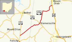
State Route 774 (SR 774) is an east–west state highway in the southwestern part of the U.S. state of Ohio. The route runs from its western terminus at SR 133 approximately 2 miles (3.2 km) north of Felicity to its eastern terminus at US 68 nearly 2 miles (3.2 km) south of Mount Orab.
| ||||
|---|---|---|---|---|
 | ||||
| Route information | ||||
| Maintained by ODOT | ||||
| Length | 14.93 mi[1] (24.03 km) | |||
| Existed | 1938[2][3]–present | |||
| Major junctions | ||||
| West end | ||||
| East end | ||||
| Location | ||||
| Counties | Clermont, Brown | |||
| Highway system | ||||
| ||||

Route description

Along its way, SR 774 traverses portions of eastern Clermont County and western Brown County. No portion of this highway is included within the National Highway System, a network of routes considered to be most important for the country's economy, mobility and defense.[4]
History
SR 774 was designated in 1938. Originally, the highway ran from its present western terminus at State Route 133 north of Felicity to its junction with SR 125 in Hamersville.[2][3] One year later, the highway was extended northeasterly to its present eastern terminus at US 68 south of Mount Orab.[5]
Major intersections
| County | Location | mi[1] | km | Destinations | Notes |
|---|---|---|---|---|---|
| Clermont | Franklin Township | 0.00 | 0.00 | ||
| Brown | Hamersville | 7.22 | 11.62 | ||
| Pike Township | 14.93 | 24.03 | |||
| 1.000 mi = 1.609 km; 1.000 km = 0.621 mi | |||||
References
- Ohio Department of Transportation. "Technical Services Straight Line Diagrams". Retrieved 2010-01-15.
- Official Ohio Highway Map (MrSID) (Map). Cartography by ODOH. Ohio Department of Highways. 1937. Retrieved 2011-01-16.
- Official Ohio Highway Map (MrSID) (Map). Cartography by ODOH. Ohio Department of Highways. 1938. Retrieved 2011-01-16.
- National Highway System: Ohio (PDF) (Map). Federal Highway Administration. December 2003. Retrieved 2011-01-16.
- Ohio Highway Map (MrSID) (Map). Cartography by ODOH. Ohio Department of Highways. 1939. Retrieved 2011-01-16.