Ohio State Route 162
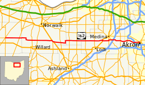
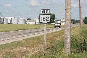
State Route 162 (SR 162) is an east–west state highway in the north central and northeastern parts of the U.S. state of Ohio. Its western terminus is in Republic at SR 18 and SR 67 and its eastern terminus is in Akron at SR 18 (the intersection of Rand and Market Street)[1] though signage along Market Street east of here shows it ending at High Street (SR 261 southbound).[2]
| ||||
|---|---|---|---|---|
 | ||||
| Route information | ||||
| Maintained by ODOT | ||||
| Length | 83.32 mi[1] (134.09 km) | |||
| Existed | 1924–present | |||
| Major junctions | ||||
| West end | ||||
| ||||
| East end | ||||
| Location | ||||
| Counties | Seneca, Huron, Lorain, Medina, Summit | |||
| Highway system | ||||
| ||||

Major intersections
| County | Location | mi[1] | km | Destinations | Notes |
|---|---|---|---|---|---|
| Seneca | Republic | 0.00 | 0.00 | ||
| 0.07 | 0.11 | ||||
| Reed Township | 8.21 | 13.21 | |||
| Huron | Greenfield Township | 16.70 | 26.88 | ||
| 19.77 | 31.82 | ||||
| Fitchville Township | 28.51 | 45.88 | Western end of US 250 / SR 13 concurrencies | ||
| 29.15 | 46.91 | Eastern end of SR 13 concurrency | |||
| 29.49 | 47.46 | Eastern end of US 250 concurrency | |||
| New London | 33.85 | 54.48 | |||
| Lorain | Rochester Township | 40.32 | 64.89 | ||
| Huntington Township | 44.72 | 71.97 | |||
| Medina | Spencer | 49.80 | 80.15 | ||
| Chatham Township | 54.96 | 88.45 | |||
| Lafayette Township | 59.75 | 96.16 | Western end of US 42 concurrency | ||
| 60.22 | 96.91 | Eastern end of US 42 concurrency | |||
| Montville Township | 63.94 | 102.90 | Western end of SR 3 concurrency | ||
| 64.43 | 103.69 | Eastern end of SR 3 concurrency | |||
| 65.85 | 105.98 | ||||
| Sharon Township | 71.40– 71.48 | 114.91– 115.04 | Traffic circle | ||
| Summit | Copley Township | 75.71– 75.76 | 121.84– 121.92 | Diamond interchange | |
| Akron | 80.12– 80.24 | 128.94– 129.13 | Exit 131 (I-77) | ||
| 83.32 | 134.09 | ||||
1.000 mi = 1.609 km; 1.000 km = 0.621 mi
| |||||
gollark: Recursive recipes (like that weird Botania 1 redstone → 2 redstone one) → PAIN.
gollark: Oh, definitely. Multiple recipe options → PAIN.
gollark: How does it handle stuff like different wood types?
gollark: But it's annoying.
gollark: I mean, there are good technical reasons for it, since handling *all* recipes is very hard.
References
- "DESTAPE". Ohio Department of Transportation. July 3, 2014. Retrieved September 2, 2014.
- Google (September 2, 2014). "Signed portion of SR 162 along Market Street in Akron" (Map). Google Maps. Google. Retrieved September 2, 2014.
External links

This article is issued from Wikipedia. The text is licensed under Creative Commons - Attribution - Sharealike. Additional terms may apply for the media files.