Ohio State Route 16
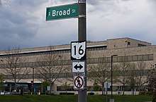
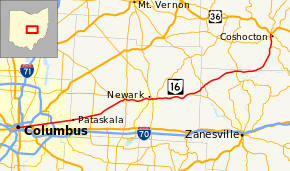
State Route 16 (SR 16) is an east–west highway running from Columbus to Coshocton. Its western terminus is at Civic Center Drive (formerly U.S. Route 33) in Downtown Columbus, and its eastern terminus is at US 36. For much of its run through Licking County, and its entire run through Franklin County, State Route 16 follows the path of Columbus' Broad Street. West of Drexel Avenue in Bexley, the route is cosigned with U.S. Route 40 until its endpoint just east of the Scioto River.
| |||||||
|---|---|---|---|---|---|---|---|
 | |||||||
| Route information | |||||||
| Maintained by ODOT | |||||||
| Length | 70.46 mi[1] (113.39 km) | ||||||
| Existed | 1926–present | ||||||
| Major junctions | |||||||
| West end | |||||||
| East end | |||||||
| Location | |||||||
| Counties | Franklin, Licking, Muskingum, Coshocton | ||||||
| Highway system | |||||||
| |||||||

History
The State Route 16 designation was originally applied to the routing carrying U.S. Route 422; when that route was created, SR 16 moved to the routing that had carried State Route 20. SR 16 was rerouted at its east end after the creation of US 36, then later truncated to Coshocton, with the eastern end becoming State Route 416.
Major intersections
| County | Location | mi[1] | km | Exit | Destinations | Notes |
|---|---|---|---|---|---|---|
| Franklin | Columbus | 0.00 | 0.00 | Western end of US 40 concurrency | ||
| 0.32 | 0.51 | Western end of US 62 westbound concurrency | ||||
| 0.41 | 0.66 | Western end of US 62 eastbound concurrency | ||||
| 1.08– 1.14 | 1.74– 1.83 | Exit 108B (I-71) | ||||
| 2.85 | 4.59 | Eastern end of US 62 concurrency | ||||
| Bexley | 3.57 | 5.75 | Eastern end of US 40 concurrency | |||
| Whitehall | 6.97 | 11.22 | ||||
| Columbus | 7.80– 8.31 | 12.55– 13.37 | Exit 39 (I-270) | |||
| Licking | Pataskala | 17.73 | 28.53 | Western end of SR 310 concurrency | ||
| 17.84 | 28.71 | Eastern end of SR 310 concurrency | ||||
| Granville Township | 26.56– 26.65 | 42.74– 42.89 | Interchange, western end of SR 37 concurrency | |||
| 26.65 | 42.89 | Western end of freeway | ||||
| 26.87– 27.23 | 43.24– 43.82 | Interchange; eastern end of SR 37 concurrency; southern terminus of SR 661 | ||||
| 27.60 | 44.42 | River Road (TR 131) | no access across SR 16 (right-in/right-out) | |||
| Granville–Newark line | 29.24– 29.94 | 47.06– 48.18 | 29[2] | Thornwood Crossing | ||
| Newark | 30.25 | 48.68 | 30 | Granville Road | Westbound exit only | |
| 30.49– 31.17 | 49.07– 50.16 | — | Country Club Drive / Church Street | Westbound entrance via West Church Street | ||
| 31.96– 32.27 | 51.43– 51.93 | — | North 21st Street | |||
| 32.50– 33.02 | 52.30– 53.14 | — | Western end of SR 79 concurrency | |||
| 32.93 | 53.00 | — | North 11th Street | Westbound exit; eastbound entrance | ||
| 33.27– 33.63 | 53.54– 54.12 | — | ||||
| 34.39– 34.64 | 55.35– 55.75 | — | Eastern end of SR 79 concurrency | |||
| 35.24– 35.55 | 56.71– 57.21 | — | O'Bannon Avenue | |||
| | 36.15– 39.45 | 58.18– 63.49 | At-grade intersections for 3.3 miles (5.3 km)[3] | |||
| Hanover Township | 43.12– 43.42 | 69.39– 69.88 | — | Western terminus of SR 146 | ||
| Muskingum | Jackson Township | 46.40– 46.94 | 74.67– 75.54 | — | ||
| 51.15– 52.09 | 82.32– 83.83 | — | Old Riley Road – Frazeysburg | |||
| Cass Township | 55.46– 56.20 | 89.25– 90.45 | — | |||
| 57.08 | 91.86 | Eastern end of freeway | ||||
| Coshocton | Jackson Township | 67.16 | 108.08 | Western end of SR 83 concurrency | ||
| Coshocton | 69.81– 70.06 | 112.35– 112.75 | Interchange | |||
| Tuscarawas Township | 70.46 | 113.39 | Eastern end of SR 83 concurrency | |||
1.000 mi = 1.609 km; 1.000 km = 0.621 mi
| ||||||
References
- "DESTAPE". Ohio Department of Transportation. July 3, 2014. Retrieved October 4, 2014.
- ODOT District 5 on Facebook
- Google (October 4, 2014). "Ohio State Route 16" (Map). Google Maps. Google. Retrieved October 4, 2014.