Ohio State Route 146
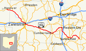
State Route 146 (SR 146) is an east-west state highway in the eastern portion of the U.S. state of Ohio. It runs 65.38 miles (105.22 km) from SR 16 near Nashport to SR 78 in Summerfield.
| ||||
|---|---|---|---|---|
 | ||||
| Route information | ||||
| Maintained by ODOT | ||||
| Length | 65.38 mi[1] (105.22 km) | |||
| Existed | 1924–present | |||
| Major junctions | ||||
| West end | ||||
| East end | ||||
| Location | ||||
| Counties | Licking, Muskingum, Guernsey, Noble | |||
| Highway system | ||||
| ||||

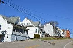
Entering Summerfield from the south
Major intersections
| County | Location | mi | km | Destinations | Notes |
|---|---|---|---|---|---|
| Licking | Hanover Township | 0.00– 0.20 | 0.00– 0.32 | Interchange | |
| Muskingum | Licking Township | 4.31 | 6.94 | Southern terminus of SR 586 | |
| Zanesville | 15.65 | 25.19 | Western end of unsigned SR 60G concurrency | ||
| 16.00 | 25.75 | Eastern end of unsigned SR 60G concurrency; western end of SR 60 concurrency | |||
| 16.75 | 26.96 | Southern terminus of SR 666 | |||
| 16.95– 17.00 | 27.28– 27.36 | Exit 155 (I-70) | |||
| 17.18 | 27.65 | Western end of US 22 / US 40 / SR 93 concurrencies | |||
| 17.30 | 27.84 | Eastern end of US 22 / US 40 / SR 93 concurrencies | |||
| 17.55 | 28.24 | Eastern end of SR 60 concurrency | |||
| Salt Creek Township | 28.02 | 45.09 | Western terminus of SR 313 | ||
| 28.12 | 45.25 | Northern terminus of SR 284 | |||
| Guernsey | Spencer Township | 37.52 | 60.38 | Western end of SR 340 concurrency | |
| Cumberland | 37.95 | 61.07 | |||
| 38.25 | 61.56 | Eastern end of SR 340 concurrency | |||
| Spencer Township | 40.41 | 65.03 | Western terminus of SR 672 | ||
| Valley Township | 45.90 | 73.87 | Western end of SR 821 concurrency | ||
| 46.03 | 74.08 | Eastern end of SR 821 concurrency | |||
| Noble | Sarahsville | 54.99 | 88.50 | Western end of SR 285 concurrency | |
| 55.04 | 88.58 | Eastern end of SR 285 concurrency | |||
| 55.16 | 88.77 | Western end of SR 147 concurrency | |||
| Center Township | 56.06 | 90.22 | Eastern end of SR 147 concurrency | ||
| Summerfield | 64.96 | 104.54 | Southern terminus of SR 513 | ||
| 65.25 | 105.01 | ||||
1.000 mi = 1.609 km; 1.000 km = 0.621 mi
| |||||
gollark: Besides, scheme would allow coolness like prisoner's-dilemma-with-visible-source at some point.
gollark: Or heavpoot's lua-based one, even.
gollark: They are not excluded. They can use scheme. I did.
gollark: Oh, well, in that case yes, subprocesses would be much slower to invoke and it would probably not be possible for me to bulk-test them like I did.
gollark: Wait, are we talking about the dilemma one or the codeguessing one?
References
- "DESTAPE". Ohio Department of Transportation. July 3, 2014. Retrieved September 3, 2014.
This article is issued from Wikipedia. The text is licensed under Creative Commons - Attribution - Sharealike. Additional terms may apply for the media files.