Ohio State Route 116
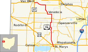
State Route 116 (SR 116) is a north–south state highway in the western portion of the U.S. state of Ohio. The highway's southern terminus is at a signalized intersection with State Route 29, State Route 66, and the eastern terminus of State Route 703 in St. Marys. Its northern terminus is at another signalized intersection, this time with U.S. Route 127 in the southern end of Van Wert.
| ||||
|---|---|---|---|---|
 | ||||
| Route information | ||||
| Maintained by ODOT | ||||
| Length | 30.93 mi[1] (49.78 km) | |||
| Existed | 1923[2][3]–present | |||
| Major junctions | ||||
| South end | ||||
| North end | ||||
| Location | ||||
| Counties | Auglaize, Van Wert | |||
| Highway system | ||||
| ||||

Route description
State Route 116 travels through the western Ohio counties of Auglaize and Van Wert. No portion of this route is included within the National Highway System, a network of highways deemed most imperative for the nation's economy, mobility and defense.[4]
History
State Route 116's designation was assigned in 1923. For the first two years of its existence, the routing of State Route 116 included the present routing of State Route 198 from downtown Wapakoneta northwest to State Route 117 east of Spencerville, State Route 117 from that point west to its eastern intersection with State Route 116, and the present alignment of State Route 116 from there to its northern terminus in Van Wert.[2][3] In 1925, State Route 116 was re-routed onto its present alignment from State Route 117 south to St. Marys. Prior to that time, this current segment of State Route 116 was designated as State Route 198. The former portions of State Route 116 were re-designated as State Route 117 and State Route 198, respectively, at that time.[5][6]
Major intersections
| County | Location | mi[1] | km | Destinations | Notes |
|---|---|---|---|---|---|
| Auglaize | St. Marys | 0.00 | 0.00 | Southern end of SR 29 concurrency, eastern terminus of SR 703 | |
| 0.50 | 0.80 | Northern end of SR 29 concurrency | |||
| Salem Township | 7.24 | 11.65 | |||
| Van Wert | Jennings Township | 13.09 | 21.07 | Southern end of SR 117 concurrency | |
| 13.59 | 21.87 | Northern end of SR 117 concurrency | |||
| 15.60 | 25.11 | ||||
| York–Jennings township line | 20.20 | 32.51 | Eastern terminus of SR 709 | ||
| Ridge Township | 24.91 | 40.09 | Western terminus of SR 697 | ||
| Van Wert | 30.81 | 49.58 | |||
1.000 mi = 1.609 km; 1.000 km = 0.621 mi
| |||||
References
- Ohio Department of Transportation. "Technical Services Straight Line Diagrams". Retrieved 2011-02-12.
- Map of Ohio State Highways (MrSID) (Map). Cartography by ODHPW. Ohio Department of Highways and Public Works. April 1922. Retrieved 2011-02-12.
- Map of Ohio Showing State Routes (MrSID) (Map). Cartography by ODHPW. Ohio Department of Highways and Public Works. July 1923. Retrieved 2011-02-12.
- National Highway System: Ohio (PDF) (Map). Federal Highway Administration. December 2003. Retrieved 2010-11-18.
- Map of Ohio Showing State Routes (MrSID) (Map). Cartography by ODHPW. Ohio Department of Highways and Public Works. August 1924. Retrieved 2011-02-12.
- Map of Ohio Showing State Routes (MrSID) (Map). Cartography by ODHPW. Ohio Department of Highways and Public Works. August 1925. Retrieved 2011-02-12.