Ohio State Route 198
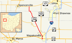
State Route 198 is a north–south state highway in the western portion of the U.S. state of Ohio. Its southern terminus is at an interchange with U.S. Route 33 just south of Wapakoneta, which is also the western terminus of State Route 67 and the southern terminus of State Route 501; its northern terminus is at State Route 117 nearly 4 miles (6.4 km) east of Spencerville.
| ||||
|---|---|---|---|---|
 | ||||
| Route information | ||||
| Maintained by ODOT | ||||
| Length | 12.52 mi[1] (20.15 km) | |||
| Existed | 1924–present | |||
| Major junctions | ||||
| South end | ||||
| North end | ||||
| Location | ||||
| Counties | Auglaize, Allen | |||
| Highway system | ||||
| ||||
Route description
No part of SR 198 in Ohio is included as a part of the National Highway System (NHS).[2] The NHS is a network of highways that are identified as being most important for the economy, mobility and defense of the nation.[3]
SR 198 heads north from an interchange with U.S. Route 33 concurrent with SR 67 and SR 501. The road enter downtown Wapakoneta where SR 67 turns east and both SR 198 and SR 501 turn west. The two routes head west and then turns towards the northwest. Just before leaving Wapakoeta SR 501 leaves the concurrency heading due north. The highway now enters rural Auglaize County passing through farmland. Before the road enters Allen County is an intersection with SR 197. The route enters Allen County and has an intersection with SR 117. This intersection is the northern terminus of SR 117.[4]
History
- 1924 – Original route established;[5] originally routed from St. Marys to 4 miles (6.4 km) west of Spencerville along current State Route 116.[6]
- 1926 – Rerouted to its current alignment, which was the former alignment of State Route 116, and from its current northern terminus to the village of Southworth along previously and currently unnumbered roads.[6]
- 1946 – Truncated at its current northern terminus; its former alignment north to Southworth decertified.[6]
- 1961 – Extended 2 miles (3.2 km) south from Wapakoneta (from its terminus at the former alignment of U.S. Route 33) to its current terminus via a previously unnumbered road.[6]
Major intersections
| County | Location | mi[1] | km | Destinations | Notes |
|---|---|---|---|---|---|
| Auglaize | Wapakoneta | 0.00 | 0.00 | Western terminus of SR 67; southern terminus of SR 198/SR 501; southern end of SR 67/SR 501 concurrency | |
| 1.18 | 1.90 | Northern end of SR 67 concurrency | |||
| 2.19 | 3.52 | Northern end of SR 501 concurrency | |||
| | 4.85 | 7.81 | Eastern terminus of SR 197 | ||
| Allen | | 12.52 | 20.15 | Northern terminus of SR 198 | |
1.000 mi = 1.609 km; 1.000 km = 0.621 mi
| |||||
References
- Ohio Department of Transportation. "Technical Services Straight Line Diagrams". Retrieved April 30, 2010.
- National Highway System: Ohio (PDF) (Map). Federal Highway Administration. December 2003. Retrieved April 4, 2012.
- "National Highway System". Federal Highway Administration. August 26, 2010. Retrieved April 4, 2012.
- Microsoft; Nokia (April 4, 2012). "Overview of SR 198 in Ohio" (Map). Bing Maps. Microsoft. Retrieved April 4, 2012.
- Explanation of the Ohio State Highway System (The Unofficial Ohio State Highways Web Site) by John Simpson Archived May 23, 2006, at the Wayback Machine
- Route 198 (The Unofficial Ohio State Highways Web Site) by John Simpson Archived January 1, 2005, at the Wayback Machine
