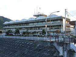
Ochiai, Okayama
Ochiai (落合町, Ochiai-chō) was a town located in Maniwa District, Okayama Prefecture, Japan.
Ochiai 落合町 | |
|---|---|
Former municipality | |
 Former Ochiai town hall | |
 Ochiai Location in Japan | |
| Coordinates: 35°1′5″N 133°45′8.5″E | |
| Country | Japan |
| Region | Chūgoku |
| Prefecture | Okayama Prefecture |
| District | Maniwa |
| Merged | March 31, 2005 (now part of Maniwa) |
| Area | |
| • Total | 147.92 km2 (57.11 sq mi) |
| Population (2003) | |
| • Total | 15,652 |
| • Density | 105.81/km2 (274.0/sq mi) |
| Symbols | |
| • Tree | Prunus mume |
| • Flower | Prunus mume |
| • Bird | Japanese bush-warbler |
| Time zone | UTC+9 (JST) |
As of 2003, the town had an estimated population of 15,652 and a density of 105.81 persons per km2. The total area was 147.92 km2.
On March 31, 2005, Ochiai, along with the town of Hokubō (from Jōbō District), and towns of Katsuyama, Kuse and Yubara, and the villages of Chūka, Kawakami, Mikamo and Yatsuka (all from Maniwa District) were merged to create the city of Maniwa.
Geography
- Rivers: Asahi River (The big-3 river through Okayama Prefecture), Bicchū River (Tributary of the Asahi River)
Education
- Amatsu Elementary School
- Ueda Elementary School
- Ueyama Branch School
- Ochiai Elementary School
- Kawahigashi Elementary School
- Kiyama Elementary School
- Hinoue Branch School
- Kōchi Elementary School
- Tsuda Elementary School
- Bessho Elementary School
- Mikawa Elementary School
- Ochiai Junior High School
- Okayama Prefectural Ochiai High School
Transportation
Railways
Road
- Expressways:
- Chūgoku Expressway
- Mimasaka-Oiwake Parking Area - Ochiai Junction - Ochiai Interchange - Maniwa Parking Area
- Yonago Expressway
- Ochiai Junction
- Chūgoku Expressway
- National highways:
- Prefectural roads:
- Okayama Prefectural Route 30 (Ochiai-Takebe)
- Okayama Prefectural Route 66 (Ochiai-Kamogawa)
- Okayama Prefectural Route 84 (Katsuyama-Kurihara)
- Okayama Prefectural Route 204 (Mimasaka-Ochiai Station)
- Okayama Prefectural Route 329 (Nishibara-Kuse)
- Okayama Prefectural Route 330 (Meki-Ōba)
- Okayama Prefectural Route 332 (Kurihara-Ukan)
- Okayama Prefectural Route 333 (Ueyama-Dando)
- Okayama Prefectural Route 370 (Eyomi-Kamigōchi)
- Okayama Prefectural Route 390 (Komi-Tsukida Station)
- Okayama Prefectural Route 411 (Tarumi-Oiwake)
- Roadside Station
- Daigo no Sato
Notable places and events
- Daigo Cherry Tree (醍醐桜, Daigo Zakura)
- A 1000+ year old cherry tree, named after the former Emperor Daigo, who commented upon the impressiveness of the tree when passing by on his way to exile in the Oki Islands.
gollark: There is more to readability than comments, also.
gollark: Write me some readable Malbolge?
gollark: I guess it is reasonable for this maybe.
gollark: ```rust//! `Slab` is backed by a `Vec` of slots. Each slot is either occupied or//! vacant. `Slab` maintains a stack of vacant slots using a linked list. To//! find a vacant slot, the stack is popped. When a slot is released, it is//! pushed onto the stack.```OH BEES A LINKED LIST WHY
gollark: Yes.
External links
- Official website of Maniwa in Japanese
- Maniwa city Ochiai area digital museum in Japanese
This article is issued from Wikipedia. The text is licensed under Creative Commons - Attribution - Sharealike. Additional terms may apply for the media files.