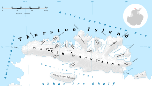
Noville Peninsula
Noville Peninsula (71°56′S 98°35′W) is a high ice-covered peninsula about 30 nautical miles (60 km) long, between Peale and Murphy Inlets on the north side of Thurston Island in Antarctica. Delineated from aerial photographs made by U.S. Navy Operation Highjump in December 1946. Named for George O. Noville, executive officer of Byrd Antarctic Expedition, 1933–35.[1]
The northern extremity of the peninsula (and Thurston Island overall) is ice-covered Cape LeBlanc. It was named by the Advisory Committee on Antarctic Names (US-ACAN) after Lieutenant Ralph P. LeBlanc, U.S. Navy Reserve, plane commander of an Operation Highjump PBM Mariner seaplane that crashed 8 nautical miles (15 km) south of this cape, on December 30, 1946. Severely injured, LeBlanc was among the six of nine aboard that survived the crash. They were rescued on January 12, 1947 by Lieutenant Commander John D. Howell, who landed a PBM in open water off the northwest edge of Noville Peninsula.[2] The west extremity of the peninsula, ice-covered Rescue Point, is so-named because the survivors were rescued there.[3][4]
The eastern extremity of the peninsula is Black Crag, a small steep cliff rock exposure just south of small Mulroy Island. Delineated from aerial photographs taken by U.S. Navy (USN) Squadron VX-6 in January 1960. Named by Advisory Committee on Antarctic Names (US-ACAN) for George H. Black, supply officer of the Byrd Antarctic Expedition (ByrdAE) in 1928–30.[5]
Mount Feury is a peak on the northeast side of the peninsula, between Sikorski Glacier and Frankenfield Glacier.[6]
Maps
- Thurston Island – Jones Mountains. 1:500000 Antarctica Sketch Map. US Geological Survey, 1967.
- Antarctic Digital Database (ADD). Scale 1:250000 topographic map of Antarctica. Scientific Committee on Antarctic Research (SCAR), 1993–2016.
References
- "Noville Peninsula". Geographic Names Information System. United States Geological Survey. Retrieved 2018-08-29.
- "Cape LeBlanc". Geographic Names Information System. United States Geological Survey. Retrieved 2013-06-07.
- "Rescue Point, Antarctica - Geographical Names, map, geographic coordinates". geographic.org. Retrieved 17 August 2018.
- "Rescue Point". Geographic Names Information System. United States Geological Survey. Retrieved 2018-08-29.
- "Black Crag". Geographic Names Information System. United States Geological Survey. Retrieved 2018-08-29.
- "Feury, Mount". Geographic Names Information System. United States Geological Survey. Retrieved 2012-03-22.
![]()