Nová Ľubovňa
Nová Ľubovňa is a village and municipality in Stará Ľubovňa District in the Prešov Region of northern Slovakia.
Nová Ľubovňa | |
|---|---|
Municipality | |
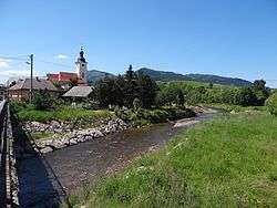 General view of the village | |
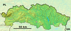 Nová Ľubovňa Location of Nová Ľubovňa in the Prešov Region  Nová Ľubovňa Nová Ľubovňa (Slovakia) | |
| Coordinates: 49°16′16″N 20°40′53″E | |
| Country | Slovakia |
| Region | Prešov |
| District | Stará Ľubovňa |
| First mentioned | 1308 |
| Area | |
| • Total | 14.433 km2 (5.573 sq mi) |
| Elevation | 562 m (1,844 ft) |
| Population | |
| • Total | 2,738 |
| • Density | 190/km2 (490/sq mi) |
| Postal code | 065 11 |
| Area code(s) | +421-52 |
| Car plate | SL |
| Website | www.novalubovna.sk |
History
In historical records the village was first mentioned in 1308.
Geography
The municipality lies at an altitude of 562 metres and covers an area of 14.433 km². It has a population of about 2738 people.
Twin towns – sister cities
Nová Ľubovňa is twinned with:[1]
gollark: (it can't actually switch users either; this is a minor detail)
gollark: See, osmarksßsystemd™ doesn't do this.
gollark: At one point its builtin DNS resolver thing had a flaw allowing denial of service.
gollark: Oh, and it has a login shell.
gollark: I mean, why would you NOT want this in an inscrutable maze of binaries which communicate only with each other?!
References
- "Partnerské obce" (in Czech). Obec Zašová. Retrieved 2019-09-07.
External links
This article is issued from Wikipedia. The text is licensed under Creative Commons - Attribution - Sharealike. Additional terms may apply for the media files.