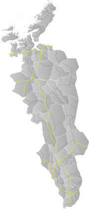
Norwegian National Road 3
Norwegian National Road 3 (Norwegian: Riksvei 3, Rv3) is a Norwegian national road that is the main route through the Østerdalen district. It has been dubbed Den grønne Snarvei 'the green shortcut' by the Hedmark county municipality.[1][2] The route runs south from European Route E6 at Ulsberg in the municipality of Rennebu in Trøndelag county, via Tynset and Elverum, to Stange in Hedmark county, where it rejoins European Route E6. The route was 291.3 kilometers (181.0 mi) long, of which 277.9 kilometers (172.7 mi) are in Hedmark county and 13.4 kilometers (8.3 mi) are in Trøndelag county.[3]
| |
|---|---|
| Bokmål: Riksvei 3 Nynorsk: Riksveg 3 | |
  | |
| Route information | |
| Length | 290.0 km (180.2 mi) |
| Major junctions | |
| North end | |
| South end | |
| Highway system | |
| National Roads in Norway | |
National Road 3 is the route most used for transport between Oslo and Trondheim, carrying approximately 90% of heavy traffic and most of the passenger car traffic between the two cities. This is because the route is about 42 kilometers (26 mi) shorter in comparison to European Route E6, has better curvature, goes through fewer towns, and has smaller grades. Unlike the E6 over the Dovrefjell mountain range, National Road 3 is also never closed due to winter weather. There have therefore been proposals to reroute the E6 to Østerdalen (along the route of National Road 3).[4] This is however not the official plan. Big money is spent to upgrade around 100 km of E6 (Øyer–Stange) to four-lane motorway and upgrade of long other parts of E6. Much less is spent on Road 3, although 14 kilometres (8.7 mi) of four-lane motorway was opened in 2020, but not much more investment is planned.
History
From 1965 to 1992, National Road 3 followed a route from Ulsberg to Kongsvinger via Tynset and Elverum. The segment between Løten and Ommangsvolden was designated National Road 211.[5] As part of the 1992 European route reform, the route from Elverum to Kongsvinger was redesignated National Road 20, and is now part of National Road 2.
A new bridge at Åsta was completed in 2014[6] and stands about 30 meters (98 ft) west of the old bridge. It is part of the newly built segment of the road between Skjærodden and Nygarden in the municipality of Åmot.
14 kilometres (8.7 mi) of four-lane motorway (between Løten and Elverum), and 9 kilometres (5.6 mi) more new road was opened in 2020.[7] This shortened route 3 around 1-2 km.
References
- "RV3 - Den grønne snarvei". Retrieved July 25, 2018.
- Vespestad, Nils Henning (February 8, 2017). "Viser fram snarvegen, og vil ha med seg flere". Østlendingen. Retrieved July 25, 2018.
- Lein, Kristian; Køhn, Espen (2004). Rv 3 – Betydning, standard og investeringsbehov (= ØF-Rapport nr. 11/2004) (PDF). Lillehammer: Østlandsforskning. p. 40. Retrieved July 25, 2018.
- Schinstad, Stein (April 12, 2007). "Flytt E6 til Østerdalen". NRK. Retrieved July 26, 2018.
- Cappelens bil- og turistkart, dobbeltblad 3-4 (Map, 1:325,000). Oslo: J. W. Cappelens Forlag. 1982.
- Stensrud, Vivian (October 3, 2014). "Ny bru på 'dødsveien'". NRK. Retrieved July 27, 2018.
- Nå er det bekreftet: Nye rv.3/25 åpner tre måneder tidligere enn planlagt
