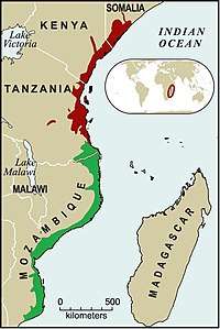
Northern Zanzibar-Inhambane coastal forest mosaic
Northern Zanzibar-Inhambane coastal forest mosaic, also known as the Northern Swahili coastal forests and woodlands,[1] is a tropical moist broadleaf forest ecoregion of coastal East Africa. The ecoregion includes a variety of habitats, including forest, savanna and swamps.
| Northern Zanzibar-Inhambane coastal forest mosaic | |
|---|---|
 Northern Zanzibar-Inhambane coastal forest mosaic
Southern Zanzibar-Inhambane coastal forest mosaic | |
| Ecology | |
| Realm | Afrotropic |
| Biome | Tropical and subtropical moist broadleaf forests |
| Geography | |
| Area | 111,900 km2 (43,200 sq mi) |
| Countries | Kenya, Somalia, Tanzania |
| Conservation | |
| Conservation status | critical/endangered |
| Global 200 | yes |
Area and limits
The ecoregion extends along the East African coast from southern Somalia through Kenya to the Lukuledi river in Tanzania, which forms its southern boundary. It also encompasses the Zanzibar Archipelago, including Unguja (Zanzibar) Pemba, and the surrounding smaller islands.[2]
The ecoregion is bounded on the east by the Indian Ocean. It transitions to drier open woodlands and shrublands to the north and west: the Somali Acacia-Commiphora bushlands and thickets in the north, the Northern Acacia-Commiphora bushlands and thickets and Southern Acacia-Commiphora bushlands and thickets west of the central portion, and the Eastern Miombo woodlands to the southwest. To the south, it borders the Southern Zanzibar-Inhambane coastal forest mosaic across the Lukuledi River.
Flora
The coastal forest mosaic is made up of several different forest and woodland types[3], including:
- Zanzibar-Inhambane lowland rain forest
- Zanzibar-Inhambane undifferentiated forest
- Zanzibar-Inhambane transitional rain forest, a mid-elevation rain forest which includes both lowland species and Afromontane species.
- Zanzibar-Inhambane scrub forest
- Zanzibar-Inhambane scrub forest on coral rag
- Zanzibar-Inhambane transition woodland, a type of miombo woodland.
Fauna
The ecoregion is home to ten endemic species of birds. Four are restricted to the island of Pemba (Treron pembaensis, Nectarinia pembae, Zosterops vaughani and Otus pembaensis). The remaining six are found on the mainland; one in the lower Tana River of Kenya (Cisticola restrictus), and four in the mainland coastal forest remnants – Erythrocercus holochlorus, Anthus sokokensis, Clarke's Weaver (Ploceus golandi), and Campethera mombassica. Anthus melindae is endemic to the coastal grasslands in Kenya.[4]
Protected areas
The VECEA team estimated that 7.9% of the 88,640 km² of coastal mosaic in Kenya and Tanzania is within protected areas explicitly designated for biodiversity, species, or landscape protection (IUCN protected area categories I through IV), and 14.8% is in areas designated for both protection and sustainable human use (IUCN protected area categories V and VI).[5] Protected areas within the ecoregion include Tana River Primate Reserve, Shimba Hills National Reserve, and Arabuko Sokoke Forest Reserve and National Park in Kenya, and Saadani National Park, Mafia Island Marine Park, and the eastern portions of Selous Game Reserve in Tanzania.[6]
External links
References
- Eric Dinerstein, David Olson, et al. (2017). An Ecoregion-Based Approach to Protecting Half the Terrestrial Realm, BioScience, Volume 67, Issue 6, June 2017, Pages 534–545, https://doi.org/10.1093/biosci/bix014
- Burgess, Neil, Jennifer D’Amico Hales, Emma Underwood (2004). Terrestrial Ecoregions of Africa and Madagascar: A Conservation Assessment. Island Press, Washington DC.
- Kindt R, van Breugel P, Orwa C, Lillesø JPB, Jamnadass R and Graudal L (2015) Useful tree species for Eastern Africa: a species selection tool based on the VECEA map. Version 2.0. World Agroforestry Centre (ICRAF) and Forest & Landscape Denmark. http://vegetationmap4africa.org
- Burgess, Neil, Jennifer D’Amico Hales, Emma Underwood (2004). Terrestrial Ecoregions of Africa and Madagascar: A Conservation Assessment. Island Press, Washington DC.