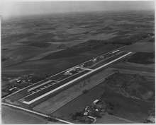
North Omaha Airport
North Omaha Airport (FAA LID: 3NO) is a privately owned, public-use airport eight miles northwest of Omaha, in Douglas County, Nebraska.[1]
North Omaha Airport | |||||||||||
|---|---|---|---|---|---|---|---|---|---|---|---|
 1975 view | |||||||||||
| Summary | |||||||||||
| Airport type | Public use | ||||||||||
| Owner | Keith Edquist | ||||||||||
| Serves | Omaha, Nebraska | ||||||||||
| Elevation AMSL | 1,322 ft / 403 m | ||||||||||
| Coordinates | 41°22′06″N 096°01′21″W | ||||||||||
| Runways | |||||||||||
| |||||||||||
| Statistics (2008) | |||||||||||
| |||||||||||
Facilities
North Omaha Airport covers 100 acres (40 ha) at an elevation of 1,322 feet (403 m). Its one runway, 17/35, is 2,480 by 40 feet (756 x 12 m) concrete.[1]
In the year ending August 13, 2008 the airport had 14,250 general aviation aircraft operations, average 39 per day. 58 aircraft were then based at the airport: 86% single-engine, 12% helicopter and 2% glider.[1]
gollark: I am, occasionally.
gollark: SSß
gollark: hAsKeLl
gollark: Haskell.
gollark: That's what they want you to think.
References
- FAA Airport Master Record for 3NO (Form 5010 PDF). Federal Aviation Administration. Effective 25 August 2011.
External links
- Resources for this airport:
- FAA airport information for 3NO
- AirNav airport information for 3NO
- FlightAware airport information and live flight tracker
- SkyVector aeronautical chart for 3NO
This article is issued from Wikipedia. The text is licensed under Creative Commons - Attribution - Sharealike. Additional terms may apply for the media files.