North Dakota Highway 20
North Dakota Highway 20 (ND 20) is a 170.550-mile-long (274.474 km) north–south highway in North Dakota. It runs from U.S. Route 52 (US 52) and US 281 in Jamestown to the Canada–United States border near Sarles. The highway continues into Manitoba as PTH 34.
| ||||
|---|---|---|---|---|
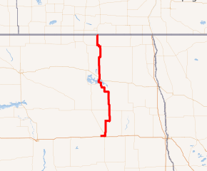
ND 20 highlighted in red | ||||
| Route information | ||||
| Maintained by NDDOT | ||||
| Length | 170.550 mi[1] (274.474 km) | |||
| Existed | 1939–present | |||
| Major junctions | ||||
| South end | ||||
| ||||
| North end | ||||
| Location | ||||
| Counties | Stutsman, Foster, Eddy, Benson, Ramsey, Cavalier | |||
| Highway system | ||||
| ||||
.svg.png)
A portion of ND 20 between mile markers 87 and 90 was closed in April 2010 due to flooding at Devils Lake and Spring Lake.[2][3]
Route description
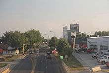
North Dakota 20 in Devils Lake, August 2013
Major intersections
| County | Location | mi[4] | km | Destinations | Notes | |||
|---|---|---|---|---|---|---|---|---|
| Stutsman | Jamestown | 0.000 | 0.000 | Southern terminus | ||||
| | 22.620 | 36.403 | Western end of ND 9 concurrency | |||||
| Courtenay | 28.003 | 45.066 | Eastern end of ND 9 concurrency | |||||
| Foster | Glenfield | 44.903 | 72.264 | |||||
| Eddy | | 61.198 | 98.489 | Southern end of ND 15 concurrency | ||||
| | 69.313 | 111.548 | Northern end of ND 15 concurrency | |||||
| Benson |
No major junctions | |||||||
| Ramsey | | 97.709 | 157.247 | Eastern terminus of ND 57 | ||||
| Devils Lake | 102.654 | 165.206 | ||||||
| 103.348 | 166.322 | Eastern terminus of ND 19 | ||||||
| | 124.464 | 200.305 | Southern end of ND 17 concurrency | |||||
| | 129.463 | 208.351 | Northern end of ND 17 concurrency | |||||
| Cavalier | | 141.255 | 227.328 | Southern end of ND 66 concurrency | ||||
| | Northern end of ND 66 concurrency | |||||||
| | 150.270 | 241.836 | Eastern end of ND 5 concurrency | |||||
| | 156.034 | 251.112 | Western end of ND 5 concurrency | |||||
| | 170.550 | 274.474 | Continuation into Manitoba | |||||
1.000 mi = 1.609 km; 1.000 km = 0.621 mi
| ||||||||
gollark: It's a good feature.
gollark: They all implode.
gollark: PIAAC level 1 says> Most of the tasks at this level require the respondent to read relatively short digital or print continuous, non-continuous, or mixed texts to locate a single piece of information that is identical to or synonymous with the information given in the question or directive. Some tasks, such as those involving non-continuous texts, may require the respondent to enter personal information onto a document. Little, if any, competing information is present. Some tasks may require simple cycling through more than one piece of information. Knowledge and skill in recognizing basic vocabulary determining the meaning of sentences, and reading paragraphs of text is expected.and 4% of people score below that, apparently.
gollark: (the live site is broken inexplicably)
gollark: https://web.archive.org/web/20210731020018/https://nces.ed.gov/pubs2019/2019179/index.asp
References
- Mileage retrieved from North Dakota Highways 1 to 30 Archived 2013-10-14 at the Wayback Machine unless otherwise noted.
- "Major Road Closed in Devils Lake Region". Retrieved 2010-06-14.
- "North Dakota Emergencies". North Dakota Department of Transportation. 2010-08-27. Archived from the original on 2010-08-29.
- "Route and Mileage Map Insets" (PDF). North Dakota Department of Transportation. North Dakota Department of Transportation. Retrieved May 3, 2017.
External links
| Wikimedia Commons has media related to North Dakota Highway 20. |
- The North Dakota Highways Page by Chris Geelhart
- North Dakota Signs by Mark O'Neil
This article is issued from Wikipedia. The text is licensed under Creative Commons - Attribution - Sharealike. Additional terms may apply for the media files.