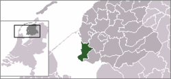
Nijefurd
Nijefurd (![]()
Nijefurd | |
|---|---|
Former municipality | |
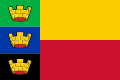 Flag  Coat of arms | |
 | |
| Coordinates: 52°59′N 5°26′E | |
| Country | Netherlands |
| Province | Friesland |
| Municipality | Súdwest-Fryslân |
| Area (2006) | |
| • Total | 289.17 km2 (111.65 sq mi) |
| • Land | 96.68 km2 (37.33 sq mi) |
| • Water | 192.49 km2 (74.32 sq mi) |
| Population (1 January, 2007) | |
| • Total | 10,887 |
| • Density | 113/km2 (290/sq mi) |
| Source: CBS, Statline. | |
| Time zone | UTC+1 (CET) |
| • Summer (DST) | UTC+2 (CEST) |
History
It was formed in 1984 from the old municipalities of Hindeloopen, Stavoren, and Workum, and part of Hemelumer Oldeferd.
In 2011, it formed together with the municipalities of Bolsward, Sneek, Wûnseradiel and Wymbritseradiel the new municipality Súdwest Fryslân.
Population centres
gollark: > And also if you have a kerosene powered plane it will become useless in however many years when a drop of oil costs $100
gollark: They aren't exactly emojis. You cannot put them inline in messages.
gollark: https://i.osmarks.tk/bees.png
gollark: Not big ones.
gollark: 🐝
This article is issued from Wikipedia. The text is licensed under Creative Commons - Attribution - Sharealike. Additional terms may apply for the media files.