Nighthawk-Chopaka Border Crossing
The Nighthawk-Chopaka Border Crossing connects the town of Loomis, Washington with the Cawston, British Columbia on the US-Canada border. The towns of Chopaka and Nighthawk effectively died off when the search for local gold proved fruitless and the Burlington Northern Railroad ceased operations in the middle of the 20th century. Canada has had a Customs office at this crossing since 1907; another crossing at Chopaka Road on the west side of the Similkameen River was equally popular until the US barricaded the road in 1964.[1]
| Nighthawk-Chopaka Border Crossing | |
|---|---|
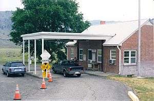
 US Border Inspection Station at Nighthawk, Washington, as seen in 1997 | |
| Location | |
| Country | United States; Canada |
| Location |
|
| Coordinates | 49.000119°N 119.670875°W |
| Details | |
| Opened | 1907 |
| US Phone | (509) 476-2125 |
| Canadian Phone | (250) 499-2755 |
| Hours | Open 9:00AM - 5:00PM |
| Website http://www.cbp.gov/contact/ports/oroville-wa | |
The crossing is the least-used in Washington, with only a few cars a day. The area west of the station is the most remote part of the contiguous US on the border, through the Cascade Mountains. The next border crossing to the west is the Sumas-Huntingdon Border Crossing, which is 125 miles from Nighthawk-Chopaka. However, many hikers on the Pacific Coast Trail cross between North Cascades National Park and Manning Park without reporting at the nearest official Port of Entry as they are supposed to.[2]
History

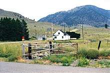
Canada first provided customs services at Chopaka in 1861, but didn't establish a permanent presence until 1907, when the Vancouver, Victoria and Eastern Railway was constructed.[3] Prior to 1950, most of the cross-border traffic in this area occurred about 2 miles to the west, on the western side of the Similkameen River. Canada built its current border station on Nighthawk Road in 1950. For many years, the US operated its border inspection services out of a trailer that was situated directly against the Canada–US border, as Similkameen Road parallels the border before turning northward at the Canada border station. In 1952, the Nighthawk border station was closed for over a year due to lack of funds.[4] In 1962, the US built a small brick border station at this crossing. A new $6 million facility was completed in 2012.[5] Nighthawk is a station of the Oroville Port of Entry.
References
- Ann Briley (April 12, 2011). "Chopaka: The early days". BC Local News. Archived from the original on December 30, 2014. Retrieved 2014-12-30.
- "Chapter 6: Washington State". United Divide: A Linear Portrait of the USA/Canada Border. The Center for Land Use Interpretation. Winter 2015.
- Legg, Herbert (1962). Customs Services in Western Canada, 1867-1925; a History, The Creston Review Ltd., Creston, BC, Page 54
- "Border Station Funds Sought". The Spokesman-Review. Associated Press. March 27, 1953. Retrieved 18 December 2015.
- Gary DeVon (May 31, 2012). "New high-tech U.S. Port of Entry facility opens at Nighthawk". Gazette-Tribune. Retrieved 2014-12-30.