Nigerian lowland forests
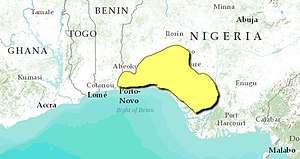
The Nigerian lowland forests is a tropical moist forest ecoregion in southwestern Nigeria and southeastern Benin. The ecoregion is densely populated, and home to several large cities including Lagos, Ibadan, and Benin City. The remaining enclaves of forest are increasingly fragmented.[1]
| Nigerian lowland forests | |
|---|---|
 Map of the Nigerian lowland forests | |
| Ecology | |
| Realm | Afrotropical |
| Biome | Tropical and subtropical moist broadleaf forests |
| Borders | Central African mangroves, Cross-Niger transition forests, Guinean forest-savanna mosaic and Niger Delta swamp forests |
| Geography | |
| Area | 67,340 km2 (26,000 sq mi) |
| Countries | Nigeria and Benin |
| Conservation | |
| Conservation status | critical/endangered |
Geography
The Nigerian lowland forests are bounded on the south by coastal mangroves and the Gulf of Guinea, on the east by the Niger River and its delta, on the north by the Guinean forest-savanna mosaic. On the west it is bounded by the Dahomey Gap, a drier coastal region where forest-savanna mosaic extends all the way to the ocean, separating the Lower Guinean forests, of which the Nigerian lowland forests are part, from the Upper Guinean forests of West Africa.[2]
Protected areas
Protected areas in the Nigerian lowland forest include:
- Akure Ofosu Forest Reserve
- Gilli-Gilli Game Reserve
- Ifon Game Reserve
- Kwale Game Reserve
- Okomu National Park
- Omo Forest Reserve
- Orle River Game Reserve
- Owo Forest Reserve