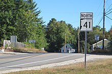
New Hampshire Route 41
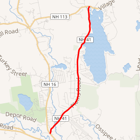
New Hampshire Route 41 (abbreviated NH 41) is a 5.033-mile-long (8.100 km) north–south state highway in east-central New Hampshire. It is the main road connecting Silver Lake with Ossipee. The highway skirts the western edge of the lake named Silver Lake and provides access to local roads at the lakeside.
| ||||
|---|---|---|---|---|
SR 41 highlighted in red | ||||
| Route information | ||||
| Maintained by NHDOT | ||||
| Length | 5.033 mi[1] (8.100 km) | |||
| Major junctions | ||||
| South end | ||||
| North end | ||||
| Location | ||||
| Counties | Carroll | |||
| Highway system | ||||
| ||||

NH 41, along with NH 113, provides an alternate to the often-congested NH 16 between Ossipee and Conway.
Route description
NH 41 begins in West Ossipee at an intersection with NH 16, just past its northern split with NH 25. NH 41 proceeds northeast, crossing through a small corner of southeastern Tamworth before entering the town of Madison. NH 41 turns due north and skirts the western edge of Silver Lake for a few miles before ending at NH 113 in the village of Silver Lake, near the lake's northern tip.
Junction list
The entire route is in Carroll County. [1][2]
| Location[1][2] | mi[1][2] | km | Destinations | Notes | |
|---|---|---|---|---|---|
| Ossipee | 0.000 | 0.000 | Southern terminus | ||
| Madison | 5.033 | 8.100 | Northern terminus | ||
| 1.000 mi = 1.609 km; 1.000 km = 0.621 mi | |||||
References
- Bureau of Planning & Community Assistance (February 20, 2015). "NH Public Roads". Concord, New Hampshire: New Hampshire Department of Transportation. Retrieved April 7, 2015.
- Bureau of Planning & Community Assistance (April 3, 2015). "Nodal Reference 2015, State of New Hampshire". New Hampshire Department of Transportation. Retrieved April 7, 2015.