New Hampshire Route 150
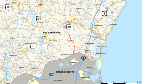
New Hampshire Route 150 (abbreviated NH 150) is a 5.743-mile (9.242 km) north–south state highway in Rockingham County in southeastern New Hampshire, United States.
| ||||
|---|---|---|---|---|
 Map of Rockingham County in southeastern New Hampshire with NH 150 highlighted in red | ||||
| Route information | ||||
| Maintained by NHDOT | ||||
| Length | 5.743 mi[1] (9.242 km) | |||
| Major junctions | ||||
| South end | ||||
| North end | ||||
| Location | ||||
| Counties | Rockingham | |||
| Highway system | ||||
| ||||
Route description

The road runs from Kensington south to the Massachusetts border.
The southern terminus of NH 150 is at the Massachusetts state line in South Hampton, where the road continues south as Massachusetts Route 150 in the town of Amesbury. The northern terminus of NH 150 is at New Hampshire Route 108 in Kensington. For most of its length, NH 150 is named Amesbury Road.
Major intersections
The entire route is in Rockingham County. [1][2]
| Location[1][2] | mi[1][2] | km | Destinations | Notes | |
|---|---|---|---|---|---|
| South Hampton | 0.000 | 0.000 | Continuation into Massachusetts. | ||
| Kensington | 1.687 | 2.715 | |||
| 2.534 | 4.078 | Western terminus of NH 84 | |||
| 5.743 | 9.242 | Northern terminus | |||
| 1.000 mi = 1.609 km; 1.000 km = 0.621 mi | |||||
In popular culture
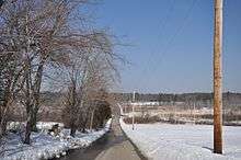
NH 150 in Kensington, near where it intersects with Brewer Road, was the location of the Exeter incident, a highly publicized UFO sighting that occurred on September 3, 1965.[3][4]
See also
- List of state highways in New Hampshire
References
- Bureau of Planning & Community Assistance (February 20, 2015). "NH Public Roads". Concord, New Hampshire: New Hampshire Department of Transportation. Retrieved April 7, 2015.
- Bureau of Planning & Community Assistance (April 3, 2015). "Nodal Reference 2015, State of New Hampshire". New Hampshire Department of Transportation. Retrieved April 7, 2015.
- Sottile, Alexis (September 18, 2018). "Geek Road Trip: New Hampshire's Massive UFO Festival". Syfy Wire. Retrieved February 7, 2019.
- "Rash of UFO Reports Flood New Hampshire Air Force Base". Bennington Banner. Bennington, Vermont. UPI. September 9, 1965. p. 11. Retrieved February 7, 2019 – via newspapers.com.
