New Hampshire Route 129
New Hampshire Route 129 (abbreviated NH 129) is an 8.724-mile-long (14.040 km) secondary east–west state highway in New Hampshire. The road runs between Loudon and Gilmanton.
| ||||
|---|---|---|---|---|
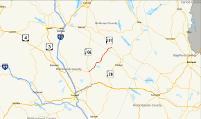 Map of central New Hampshire with NH 129 highlighted in red | ||||
| Route information | ||||
| Maintained by NHDOT | ||||
| Length | 8.724 mi[1] (14.040 km) | |||
| Major junctions | ||||
| West end | South Village Road in Loudon | |||
| East end | ||||
| Location | ||||
| Counties | Merrimack, Belknap | |||
| Highway system | ||||
| ||||

The southwestern terminus of NH 129 is in Loudon at South Village Road, west of the intersection with New Hampshire Route 106. The northeastern terminus is at New Hampshire Route 107 in Gilmanton.
Major intersections
| County | Location[1][2] | mi[1][2] | km | Destinations | Notes |
|---|---|---|---|---|---|
| Merrimack | Loudon | 0.000 | 0.000 | ||
| Belknap | Gilmanton | 8.724 | 14.040 | ||
| 1.000 mi = 1.609 km; 1.000 km = 0.621 mi | |||||
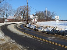
NH 129 in northeastern Loudon
gollark: Describing the issue in question more usefully?
gollark: Can you create a ticket on the issue tracker?
gollark: They work fine.
gollark: There is ONE.
gollark: They are NOT cheap.
References
- Bureau of Planning & Community Assistance (February 20, 2015). "NH Public Roads". Concord, New Hampshire: New Hampshire Department of Transportation. Retrieved April 7, 2015.
- Bureau of Planning & Community Assistance (April 3, 2015). "Nodal Reference 2015, State of New Hampshire". New Hampshire Department of Transportation. Retrieved April 7, 2015.
This article is issued from Wikipedia. The text is licensed under Creative Commons - Attribution - Sharealike. Additional terms may apply for the media files.