New Hampshire Route 117
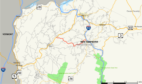
New Hampshire Route 117 (abbreviated NH 117) is an 8.095-mile-long (13.028 km) east–west highway in northern New Hampshire. NH 117 runs from Franconia to Lisbon in the White Mountains Region.
| ||||
|---|---|---|---|---|
| Sugar Hill Road | ||||
 Map of Grafton County in northwestern New Hampshire with NH 117 highlighted in red | ||||
| Route information | ||||
| Maintained by NHDOT | ||||
| Length | 8.095 mi[1] (13.028 km) | |||
| Major junctions | ||||
| West end | ||||
| East end | ||||
| Location | ||||
| Counties | Grafton | |||
| Highway system | ||||
| ||||
The eastern terminus of NH 117 is at New Hampshire Route 18 and New Hampshire Route 116 in Franconia, where NH 117 is named Sugar Hill Road. The western terminus of NH 117 is in Lisbon at U.S. Route 302 and New Hampshire Route 10.
Major intersections
The entire route is in Grafton County. [1][2]
| Location[1][2] | mi[1][2] | km | Destinations | Notes | |
|---|---|---|---|---|---|
| Lisbon | 0.000 | 0.000 | |||
| Franconia | 8.095 | 13.028 | |||
| 1.000 mi = 1.609 km; 1.000 km = 0.621 mi | |||||
gollark: The next big trend in phone cameras is going to be IR/UV sensors, mark my words.
gollark: The next big trend in phone cameras is going to be IR/UV sensors, mark my words.
gollark: I would really like a modern-ish phone with... well, 4G and the ability to run a browser, I don't really need applications much... which is actually durable.
gollark: Sounds pointlessly expensive.
gollark: I tend to drop my phone and stuff constantly, so not having a case would be silly.
References
- Bureau of Planning & Community Assistance (February 20, 2015). "NH Public Roads". Concord, New Hampshire: New Hampshire Department of Transportation. Retrieved April 7, 2015.
- Bureau of Planning & Community Assistance (April 3, 2015). "Nodal Reference 2015, State of New Hampshire". New Hampshire Department of Transportation. Retrieved April 7, 2015.
This article is issued from Wikipedia. The text is licensed under Creative Commons - Attribution - Sharealike. Additional terms may apply for the media files.
