Nevada State Route 486
State Route 486 (SR 486) was a state highway in White Pine County, Nevada. The roadway was turned over to local control in the 1990s.
| ||||
|---|---|---|---|---|
| Duck Creek Road | ||||

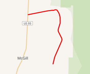
SR 486 highlighted in red | ||||
| Route information | ||||
| Length | 10.5 mi[1] (16.9 km) | |||
| Major junctions | ||||
| South end | Duck Creek Valley | |||
| North end | ||||
| Highway system | ||||
| ||||
Route description
Immediately before the route number was retired, the SR 486 designation encompassed Duck Creek Road, which started at the south end of pavement in the middle of Duck Creek Valley. It went north down the valley, then turned west and exited at Gallagher Gap, following the course of Duck Creek. Once through the gap, it continued west until it intersected U.S. Route 93 (US 93), where it ended.
History
The road extending east from US 93 to Duck Creek Valley (Duck Creek Road), south over Success Summit to Cave Lake State Park (Success Summit Road), and back west to U.S. Route 6/50/93 (Steptoe Creek Road) appeared on state maps before the 1976 renumbering of Nevada's state routes, but had no state designation. The designation of SR 486 was first seen on state highway maps in 1978 and included the entire loop (known as Success Loop[2][3]), but was scaled back to the paved northern portion by 1982. SR 486 remained unchanged on official maps until 1995, when the route number was removed from the state highway map.[4] The entire loop is now part of White Pine County Route 29,[1][5] though some agencies, including the Nevada Division of State Parks and Humboldt-Toiyabe National Forest, still refer to part or all of the road as SR 486.[6][7]
See also


References
- Google (11 August 2014). "Nevada State Route 486" (Map). Google Maps. Google. Retrieved 11 August 2014.
- "The Success Loop Scenic Drive". ExploreNevada.com. Retrieved 2014-08-19.
- "Trip of the Week: Enjoy scenic drive on Success Summit Loop near Ely". Las Vegas Review Journal. Retrieved 2014-08-19.
- "Historical Maps". Nevada Department of Transportation. Archived from the original on August 9, 2013. Retrieved August 11, 2014.
- Nevada Road & Recreation Atlas (Map). 1:280000. Benchmark Maps. 2007. p. 62-63. ISBN 0-929591-95-X.
- "Cave Lake State Park". Nevada Division of State Parks. Retrieved 2014-08-17.
- "Humboldt-Toiyabe National Forest - High Schells Wilderness". United States Forest Service. Retrieved 2014-08-19.
| Wikimedia Commons has media related to Nevada State Route 486 (former). |
