Nevada State Route 485
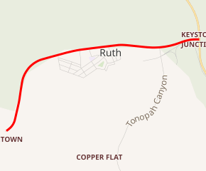
State Route 485 (SR 485) was a state highway in White Pine County, Nevada. It provided access to the town of Ruth. The roadway was turned over to local control in the 1980s.
| ||||
|---|---|---|---|---|

SR 485 highlighted in red | ||||
| Route information | ||||
| Length | 3 mi (5 km) | |||
| Existed | 1976–by 1982 | |||
| History | Established as SR 44 by 1935 | |||
| Major junctions | ||||
| West end | Ruth | |||
| East end | ||||
| Highway system | ||||
| ||||
Route description
SR 485 started at U.S. Route 50 (US 50), about 6 miles (9.7 km) west of Ely. SR 485 ran 2 miles (3.2 km) west to the mining town of Ruth.[1] The road's pavement ends slightly west of Ruth, although a dirt road continues back near the former site of Riepetown.
History
The road to Ruth was established as State Route 44 by 1935. At that time, the route was shown on official state maps as being a paved road connecting the former town of Kimberly to US 50 via Ruth.[2] By 1941, SR 44 appears to have been altered and then comprised two roadways, a three-mile (4.8 km) road to Ruth and a four-mile (6.4 km) spur to Kimberly;.[3] a routing which was defined by state highway law.[4] Although maps are unclear, it appears the road to Ruth was eliminated prior to 1964, and the spur to Kimberly was retained as SR 44.[5] The town of Ruth may have been relocated along the highway as well, in concordance with open pit mining operations in the area.
SR 44 remained unchanged for many years, until the 1976 renumbering of Nevada's state highways. In that process, SR 44 was to be replaced by SR 485.[6] However, the new designation was not retained through the state's renumbering process; SR 485 last appeared on the 1980–1981 state highway map while the numbering transition was still underway.[7][8]
See also


References
| Wikimedia Commons has media related to Nevada State Route 485 (former). |
- "Ruth, Nevada". Archived from the original on 2008-12-24. Retrieved 2008-11-19.
- Official Road Map of the State of Nevada (Map). Nevada Department of Highways. 1935. Retrieved April 5, 2015.
- Official Road Map of the State of Nevada (Map). Nevada Department of Highways. 1941. Retrieved April 5, 2015.
- Laws Relating to Highways and State Parks. Carson City, Nevada: State of Nevada. 1951.
- Official Highway Map of Nevada (Map) (1963-1964 ed.). Nevada State Highway Department. 1963. § D6. Retrieved April 5, 2015.
- Official Highway Map of Nevada (Map) (1978-79 ed.). Nevada State Highway Department. 1978. § C5-C6. Retrieved April 5, 2015.
- Official Highway Map of Nevada (Map) (1980-81 ed.). Nevada State Department of Transportation. 1980. § C5-C6. Retrieved April 5, 2015.
- Official Highway Map of Nevada (Map) (1982 ed.). Nevada State Department of Transportation. 1982. § C5-C6. Retrieved April 5, 2015.
