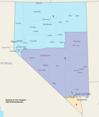
Nevada's congressional districts
Nevada is divided into four congressional districts, each represented by a member of the United States House of Representatives. After the 2010 Census, Nevada gained a fourth House seat.

Current districts and representatives
List of members of the Nevada United States House delegation, district boundaries, and the district political ratings according to the CPVI. In the 116th United States Congress the delegation has four members, with three Democrats and one Republican.
| District | Representative | Party | CPVI | Incumbent time in office | District map |
|---|---|---|---|---|---|
| 1st | .jpg) |
Democratic | D+15 | January 3, 2013 – present | .tif.png) |
| 2nd | .jpg) |
Republican | R+7 | September 13, 2011 – present | .tif.png) |
| 3rd |  |
Democratic | R+2 | January 3, 2019 – present | .tif.png) |
| 4th |  |
Democratic | D+3 | January 3, 2019 – present | .tif.png) |
Historical and present district boundaries
Table of United States congressional district boundary maps in the State of Nevada, presented chronologically.[2] All redistricting events that took place in Nevada between 1983 and 2013 are shown.
| Year | Statewide map | Las Vegas highlight |
|---|---|---|
| 1983–1992 |  |
%2C_1983_%E2%80%93_1992.tif.png) |
| 1993–2002 |  |
%2C_1993_%E2%80%93_2002.tif.png) |
| 2003–2013 |  |
%2C_2003_%E2%80%93_2013.tif.png) |
| Since 2013 |  |
%2C_since_2013.tif.png) |
Obsolete districts
gollark: I too want to ship a large and probably slow Lua VM with my application.
gollark: At this point I'm actually very tempted to just use BBCode or something.
gollark: Unfortunately it has a weird bug with emphasis/bold and punctuation in some places, so I had to look at this.
gollark: I'm using an existing Markdown parsing library and using its vaguely tokenized output to produce virtual DOM.
gollark: This is an actual regex used to parse Markdown by one project:```^(?:(\*(?=[`\]!"#$%&'()+\-./:;<=>?@\[^_{|}~]))|\*)(?![\*\s])((?:(?:(?!\[.*?\]|`.*?`|<.*?>)(?:[^\*]|[\\s]\*)|\[.*?\]|`.*?`|<.*?>)|(?:(?:(?!\[.*?\]|`.*?`|<.*?>)(?:[^\*]|[\\s]\*)|\[.*?\]|`.*?`|<.*?>)*?(?<!\)\*){2})*?)(?:(?<![`\s\]!"#$%&'()+\-./:;<=>?@\[^_{|}~])\*(?!\*)|(?<=[`\]!"#$%&'()+\-./:;<=>?@\[^_{|}~])\*(?!\*)(?:(?=[`\s\]!"#$%&'()+\-./:;<=>?@\[^_{|}~]|$)))|^_([^\s_])_(?!_)|^_([^\s_<][\s\S]*?[^\s_])_(?!_|[^\s,!"#$%&'()+\-./:;<=>?@\[^_{|}~])|^_([^\s_<][\s\S]*?[^\s])_(?!_|[^\s,!"#$%&'()+\-./:;<=>?@\[^_{|}~])```(it's generated from a slightly less insane one with`punctuation` in place of the big mess of punctuation characters, to be fair)
See also
References
- "The national atlas". nationalatlas.gov. Archived from the original on February 22, 2014. Retrieved February 22, 2014.
- "Digital Boundary Definitions of United States Congressional Districts, 1789–2012". Retrieved October 18, 2014.
This article is issued from Wikipedia. The text is licensed under Creative Commons - Attribution - Sharealike. Additional terms may apply for the media files.