Nembe
Nembe is a Local Government Area of Bayelsa State, Nigeria. Its headquarters are in the town of Nembe in the east of the area at4°32′22″N 6°24′01″E.
Nembe | |
|---|---|
LGA and town | |
 Nembe Location in Nigeria | |
| Coordinates: 4°32′N 6°17′E | |
| Country | |
| State | Bayelsa State |
| Headquarters | Nembe |
| Area | |
| • Total | 760 km2 (290 sq mi) |
| Population (2006 census) | |
| • Total | 130,931 |
| Time zone | UTC+1 (WAT) |
| 3-digit postal code prefix | 562 |
| ISO 3166 code | NG.BY.NE |
It has an area of 760 km² and a population of 130,931 at the 2006 census. The postal code of the area is 562.[1] Much of the area of the LGA is occupied by the Edumanom National Forest.
The city is the base for the Nembe Kingdom, a traditional state.[2]
Notable people
gollark: That is also a random file.
gollark: Deserves WHAT?
gollark: Who wants RANDOM FILES?
gollark: Personally, I do not utilize drug™, not even cofe™.
gollark: Those must be some druggy drugs.
References
- "Post Offices- with map of LGA". NIPOST. Archived from the original on 2012-11-26. Retrieved 2009-10-20.
- Mogens Herman Hansen (2000). A comparative study of thirty city-state cultures: an investigation. Kgl. Danske Videnskabernes Selskab. p. 534. ISBN 87-7876-177-8.
State capital: Yenagoa | ||
| Local Government Areas | 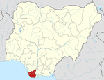 | |
This article is issued from Wikipedia. The text is licensed under Creative Commons - Attribution - Sharealike. Additional terms may apply for the media files.