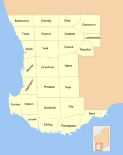
Nelson County, Western Australia
Nelson County was one of the 26 counties of Western Australia that were designated in 1829 as cadastral divisions.[1]

26 counties of Western Australia
It approximately corresponds to the northern part of the Nelson Land District which forms the basis for land titles in the area.
Notes
- John Sands (Firm) (1886), Map of Section 1 including counties of Beaufort, Carnarvon, Durham, Glenelg, Goderich, Grantham, Grey, Hay, Howick, Kent, Lanark, Lansdowne, Melbourne, Minto, Murray, Nelson, Peel, Perth, Plantagenet, Stirling, Sussex, Twiss, Victoria, Wellington, Wicklow, York, J. Sands, retrieved 15 September 2019
gollark: The problem is that it discounts the possibilities other than "god specific to known religion" and "no god".
gollark: IT IS BAD
gollark: DO NOT PASCAL'S WAGER
gollark: PASCAL'S WAGER AÆÆÆÆÆÆÆÆÆÆÆ
gollark: Fewer atheists, and probably, yes.
This article is issued from Wikipedia. The text is licensed under Creative Commons - Attribution - Sharealike. Additional terms may apply for the media files.