Needmore, Butler County, Kentucky
Needmore is an unincorporated community in Butler County, Kentucky, United States.[1] Needmore is located on U.S. Route 231 8.1 miles (13.0 km) south-southeast of Morgantown.[2]
Needmore, Kentucky | |
|---|---|
Unincorporated community | |
 Needmore, Kentucky | |
| Coordinates: 37°06′39″N 86°39′04″W | |
| Country | United States |
| State | Kentucky |
| County | Butler |
| Elevation | 495 ft (151 m) |
| Time zone | UTC-6 (Central (CST)) |
| • Summer (DST) | UTC-5 (CDT) |
| Area code(s) | 270 |
| GNIS feature ID | 508681[1] |
Notes
- "Needmore". Geographic Names Information System. United States Geological Survey.
- State Primary Road System: Butler County (PDF) (Map). Kentucky Transportation Cabinet. 2012. Retrieved May 30, 2013.
Municipalities and communities of Butler County, Kentucky, United States | ||
|---|---|---|
| Cities | 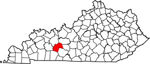 Location of Butler County, Kentucky | |
| Unincorporated communities | ||
| Footnotes | ‡This populated place also has portions in an adjacent county or counties | |
gollark: I'm glad you agree with me.
gollark: LyricLy should really be banned from participating if they're going to keep accessing this kind of information.
gollark: ALL of which are mine.
gollark: No you don't.
gollark: Yes you are, actually, when I win.
This article is issued from Wikipedia. The text is licensed under Creative Commons - Attribution - Sharealike. Additional terms may apply for the media files.