National Register of Historic Places listings in Yukon-Charley Rivers National Preserve
This is a list of the National Register of Historic Places listings in Yukon-Charley National Preserve.
This is intended to be a complete list of the properties and districts on the National Register of Historic Places in Yukon-Charley Rivers National Preserve, Alaska, United States. The locations of National Register properties and districts for which the latitude and longitude coordinates are included below, may be seen in a Google map.[1]
There are 5 properties and districts listed on the National Register in the preserve.
- This National Park Service list is complete through NPS recent listings posted August 14, 2020.[2]
Current listings
| [3] | Name on the Register[4] | Image | Date listed[5] | Location | City or town | Description |
|---|---|---|---|---|---|---|
| 1 | Ed Beiderman Fish Camp |  Ed Beiderman Fish Camp |
July 20, 1987 (#87001204) |
Left bank of Yukon River, about 56 miles (90 km) northwest of Eagle 65°22′34″N 142°32′18″W |
Eagle | |
| 2 | Coal Creek Historic Mining District |  Coal Creek Historic Mining District |
May 4, 1995 (#95000573) |
Along Coal Creek, about 44 miles (71 km) southeast of Circle 65°18′12″N 143°09′22″W |
Circle | |
| 3 | George McGregor Cabin | 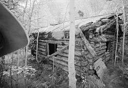 George McGregor Cabin |
July 21, 1987 (#87001199) |
About 2 miles (3.2 km) west of Coal Creek 65°21′11″N 143°11′48″W |
Eagle | |
| 4 | Frank Slaven Roadhouse | .jpg) Frank Slaven Roadhouse |
July 20, 1987 (#87001202) |
Mouth of Coal Creek, about 42 miles (68 km) southeast of Circle 65°21′02″N 143°07′22″W |
Circle | |
| 5 | Woodchopper Roadhouse |  Woodchopper Roadhouse |
July 20, 1987 (#87001201) |
About 1 mile (1.6 km) east of Woodchopper Creek 65°21′22″N 143°18′17″W |
Circle |
gollark: Well, that's not physically realisable.
gollark: I don't think that's right.
gollark: "A pi number"?
gollark: Oh.
gollark: Become several tau neutrinos.
See also
References
| Wikimedia Commons has media related to National Register of Historic Places in Yukon-Charley Rivers National Preserve. |
- The latitude and longitude information provided in this table was derived originally from the National Register Information System, which has been found to be fairly accurate for about 99% of listings. Some locations in this table may have been corrected to current GPS standards.
- "National Register of Historic Places: Weekly List Actions". National Park Service, United States Department of the Interior. Retrieved on August 14, 2020.
- Numbers represent an ordering by significant words. Various colorings, defined here, differentiate National Historic Landmarks and historic districts from other NRHP buildings, structures, sites or objects.
- "National Register Information System". National Register of Historic Places. National Park Service. April 24, 2008.
- The eight-digit number below each date is the number assigned to each location in the National Register Information System database, which can be viewed by clicking the number.
| Topics | |
|---|---|
| Lists by state |
|
| Lists by insular areas | |
| Lists by associated state | |
| Other areas | |
| Related | |
| |
This article is issued from Wikipedia. The text is licensed under Creative Commons - Attribution - Sharealike. Additional terms may apply for the media files.