National Register of Historic Places listings in Yuba County, California
This is a list of the National Register of Historic Places listings in Yuba County, California.

Location of Yuba County in California
This is intended to be a complete list of the properties and districts on the National Register of Historic Places in Yuba County, California, United States. Latitude and longitude coordinates are provided for many National Register properties and districts; these locations may be seen together in a Google map.[1]
There are 11 properties and districts listed on the National Register in the county. Another 2 properties were once listed but have been removed.
- This National Park Service list is complete through NPS recent listings posted August 14, 2020.[2]
Current listings
| [3] | Name on the Register[4] | Image | Date listed[5] | Location | City or town | Description |
|---|---|---|---|---|---|---|
| 1 | Bok Kai Temple | 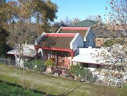 Bok Kai Temple |
May 21, 1975 (#75000498) |
Yuba River Levee at D St. 39°08′06″N 121°35′13″W |
Marysville | |
| 2 | Hart Building | 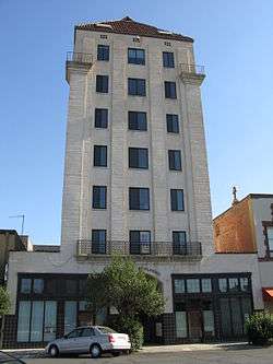 Hart Building |
January 28, 1982 (#82002285) |
423-425 4th St. 39°08′22″N 121°35′19″W |
Marysville | |
| 3 | Johnson Ranch and Burtis Hotel Sites |  Johnson Ranch and Burtis Hotel Sites |
July 22, 1991 (#91000919) |
Address Restricted |
Wheatland | |
| 4 | Marysville Historic Commercial District | 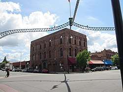 Marysville Historic Commercial District |
June 10, 1999 (#99000692) |
Roughly bounded by First, Sixth, C, and E Sts. 39°08′18″N 121°35′19″W |
Marysville | |
| 5 | Warren P. Miller House | 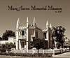 Warren P. Miller House |
March 12, 1998 (#98000225) |
704 D St. 39°08′34″N 121°35′23″W |
Marysville | |
| 6 | Oregon Creek Covered Bridge | 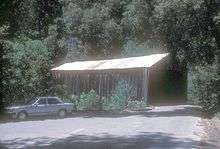 Oregon Creek Covered Bridge |
May 30, 1975 (#75000499) |
3 miles (4.8 km) northeast of North San Juan over Oregon Creek 39°23′48″N 121°04′52″W |
North San Juan | |
| 7 | Packard Library | 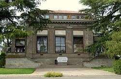 Packard Library |
December 18, 1978 (#78000829) |
301 4th St. 39°08′23″N 121°35′16″W |
Marysville | |
| 8 | Jose Manuel Ramirez House | 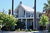 Jose Manuel Ramirez House |
January 17, 1976 (#76000545) |
220 5th St. 39°08′25″N 121°35′13″W |
Marysville | |
| 9 | U.S. Post Office – Marysville Main |  U.S. Post Office – Marysville Main |
January 11, 1985 (#85000143) |
407 C St. 39°08′23″N 121°35′13″W |
Marysville | |
| 10 | Wheatland Masonic Temple | 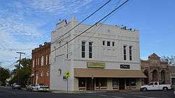 Wheatland Masonic Temple |
December 23, 1993 (#93001396) |
400 Front St. 39°00′40″N 121°25′20″W |
Wheatland | |
| 11 | Woodleaf Hotel | 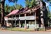 Woodleaf Hotel |
April 9, 1975 (#75000500) |
Marysville-La Porte Rd. 39°31′04″N 121°11′26″W |
Woodleaf |
Former listings
| [3] | Name on the Register | Image | Date listed | Date removed | Location | City or town | Summary |
|---|---|---|---|---|---|---|---|
| 1 | Decker-Jewett Bank | December 22, 1976 (#76000543) | Unknown | 212 D St. |
Marysville | ||
| 2 | Ellis Building | December 22, 1976 (#76000544) | Unknown | 100 D St. |
Marysville |
gollark: Perhaps the answer lies in competition maths problems. Those generally have something weird like the year as a solution, so they could probably be tweaked to 1, right?
gollark: Of course, a smart person would just type it into wolframalpha. I'll check if it accepts this.
gollark: Yes, that.
gollark: Dan just said it had to be a very hard problem which is also hard to understand for laymen with an answer of 1.
gollark: I see.
See also
| Wikimedia Commons has media related to National Register of Historic Places in Yuba County, California. |
References
- The latitude and longitude information provided in this table was derived originally from the National Register Information System, which has been found to be fairly accurate for about 99% of listings. Some locations in this table may have been corrected to current GPS standards.
- "National Register of Historic Places: Weekly List Actions". National Park Service, United States Department of the Interior. Retrieved on August 14, 2020.
- Numbers represent an ordering by significant words. Various colorings, defined here, differentiate National Historic Landmarks and historic districts from other NRHP buildings, structures, sites or objects.
- "National Register Information System". National Register of Historic Places. National Park Service. July 9, 2010.
- The eight-digit number below each date is the number assigned to each location in the National Register Information System database, which can be viewed by clicking the number.
| Topics | |
|---|---|
| Lists by state |
|
| Lists by insular areas | |
| Lists by associated state | |
| Other areas | |
| Related | |
| |
This article is issued from Wikipedia. The text is licensed under Creative Commons - Attribution - Sharealike. Additional terms may apply for the media files.