National Register of Historic Places listings in St. Clair County, Michigan
The following is a list of Registered Historic Places in St. Clair County, Michigan.
- This National Park Service list is complete through NPS recent listings posted August 14, 2020.[1]
| [2] | Name on the Register[3] | Image | Date listed[4] | Location | City or town | Description |
|---|---|---|---|---|---|---|
| 1 | Colony Tower Complex | 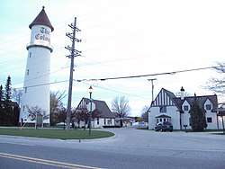 Colony Tower Complex |
July 22, 1994 (#94000756) |
6503 Dyke Rd. (M-29), Clay Township 42°37′56″N 82°36′57″W |
Pearl Beach | Boundary increase (added 1995-07-21): 6503 Dyke Rd. (MI 29), Clay Township |
| 2 | Wilbur F. Davidson House |  Wilbur F. Davidson House |
October 5, 1972 (#72001306) |
1707 Military St. 42°57′59″N 82°25′30″W |
Port Huron | |
| 3 | Federal Building | .jpg) Federal Building |
August 7, 1974 (#74002047) |
526 Water St. 42°58′29″N 82°25′34″W |
Port Huron | |
| 4 | Fort Gratiot | .jpg) Fort Gratiot |
April 14, 1980 (#80004069) |
Along Thomas Edison Parkway [5][6] 42°59′42″N 82°25′41″W |
Port Huron | |
| 5 | Fort Gratiot Lighthouse |  Fort Gratiot Lighthouse |
July 30, 1976 (#76001975) |
Omar and Garfield Sts. 43°00′23″N 82°25′21″W |
Port Huron | |
| 6 | Grand Trunk Western Railroad Depot | 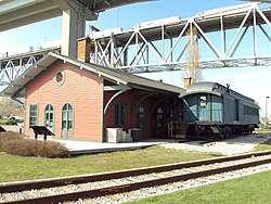 Grand Trunk Western Railroad Depot |
April 13, 1977 (#77001397) |
520 State St. 42°59′55″N 82°25′34″W |
Port Huron | |
| 7 | Harrington Hotel | 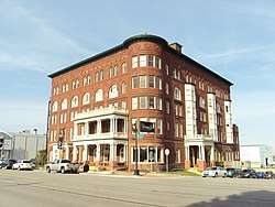 Harrington Hotel |
April 22, 1982 (#82004468) |
1026 Military Street 42°58′22″N 82°25′28″W |
Port Huron | |
| 8 | Howard Block |  Howard Block |
March 17, 1994 (#94000251) |
201-205 Huron Ave. 42°58′35″N 82°25′29″W |
Port Huron | |
| 9 | Huron (lightship) | .jpg) Huron (lightship) |
July 12, 1976 (#76001974) |
Pine Grove Park on the St. Clair River 42°59′21″N 82°25′36″W |
Port Huron | |
| 10 | Jeddo Road–South Branch Mill Creek Drain Bridge |  Jeddo Road–South Branch Mill Creek Drain Bridge |
January 28, 2000 (#00000013) |
Jeddo Rd. over S. Branch Mill Creek Drain 43°08′36″N 82°50′13″W |
Brockway Township | |
| 11 | Ladies of the Maccabees Building | 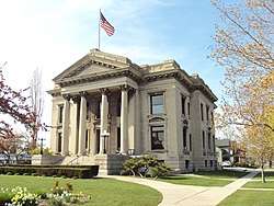 Ladies of the Maccabees Building |
April 22, 1982 (#82004469) |
901 Huron Ave. 42°59′00″N 82°25′29″W |
Port Huron | |
| 12 | Marine City City Hall | 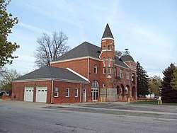 Marine City City Hall |
January 11, 1982 (#82004466) |
300 Broadway St. 42°43′10″N 82°29′35″W |
Marine City | |
| 13 | Marine City Water Works |  Marine City Water Works |
September 15, 2011 (#11000667) |
229 S. Main St. 42°43′03″N 82°29′36″W |
Marine City | |
| 14 | Masters Road–Belle River Bridge | 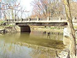 Masters Road–Belle River Bridge |
January 27, 2000 (#99001728) |
Masters Rd. over the Belle R. 42°56′24″N 82°49′50″W |
Riley Township | |
| 15 | James McColl House |  James McColl House |
January 31, 1985 (#85000170) |
205 S. Main St. 43°07′36″N 82°47′55″W |
Yale | |
| 16 | Military Road Historic District |  Military Road Historic District |
August 14, 1998 (#98001059) |
Military St. and Huron Ave., from Court St. to Bard St. 42°58′34″N 82°25′31″W |
Port Huron | |
| 17 | St. Clair Flats South Channel Range Lights |  St. Clair Flats South Channel Range Lights |
May 24, 1990 (#90000853) |
0.6 mi (0.97 km) west of the southern tip of Harsens Island 42°32′15″N 82°41′41″W |
Algonac | |
| 18 | St. Clair Inn |  St. Clair Inn |
July 3, 1995 (#95000074) |
500 N. Riverside Ave. 42°49′40″N 82°29′04″W |
St. Clair | |
| 19 | St. Clair River Tunnel | .jpg) St. Clair River Tunnel |
October 15, 1970 (#70000684) |
St. Clair River between Port Huron, Michigan and Sarnia, Ontario 42°57′30″N 82°24′38″W |
Port Huron | |
| 20 | Seventh Street–Black River Bridge |  Seventh Street–Black River Bridge |
February 4, 2000 (#00000045) |
Seventh St. over the Black River 42°58′34″N 82°25′39″W |
Port Huron | |
| 21 | LeRoy Smith House |  LeRoy Smith House |
April 4, 1996 (#96000365) |
9503 Frank St. 42°38′31″N 82°30′50″W |
Algonac | |
| 22 | USCGC Bramble |  USCGC Bramble |
August 1, 2012 (#12000457) |
2336 Military St. 42°57′36″N 82°25′32″W |
Port Huron | |
| 23 | Vernier Street–Swan Creek Bridge |  Vernier Street–Swan Creek Bridge |
January 28, 2000 (#00000011) |
Vernier St. over Swan Creek 42°40′50″N 82°39′29″W |
Ira Township | The bridge was demolished in 2014.[7] |
| 24 | Wadhams Road–Pine River Bridge | Wadhams Road–Pine River Bridge |
January 28, 2000 (#00000014) |
Wadhams Rd. over the Pine River 42°52′17″N 82°33′28″W |
Saint Clair Township | The bridge was demolished in 2007.[8] |
| 25 | Ward-Holland House |  Ward-Holland House |
January 13, 1972 (#72001305) |
433 N. Main St. 42°43′26″N 82°29′22″W |
Marine City |
Listings Formerly Located in St. Clair County
The following listings were located in St. Clair County at the time they were placed on the Register, but have since moved to other locations.
| Name on the Register |
Image | Date listed | Current Location | Location when Listed | Description | |
|---|---|---|---|---|---|---|
| 1 | Indian Trail Road–Belle River Bridge | Indian Trail Road–Belle River Bridge |
January 28, 2000 (#00000012) |
Steel Bridge Research, Inspection, Training and Engineering Center, S. Sharon Chapel Rd., West Lafayette, Indiana 40°24′31″N 86°57′02″W |
Indian Trail Rd. over Belle River 42°46′30″N 82°32′58″W | Removed and replaced in 2008, then moved to West Lafayette, Indiana in 2015.[9] |
gollark: Yes. This is documented in GTech™ Basement Site-293838F, room H/30.
gollark: You don't actually need to *ping* it, just mention it.
gollark: Too bad.
gollark: You can actually do that too. Simply ping someone and the <@&832006325491335168> role at once while possessing it.
gollark: Implementing...
See also
| Wikimedia Commons has media related to National Register of Historic Places in St. Clair County, Michigan. |
- List of Registered Historic Places in Michigan
- List of Michigan State Historic Sites in St. Clair County, Michigan
References
- "National Register of Historic Places: Weekly List Actions". National Park Service, United States Department of the Interior. Retrieved on August 14, 2020.
- Numbers represent an ordering by significant words. Various colorings, defined here, differentiate National Historic Landmarks and historic districts from other NRHP buildings, structures, sites or objects.
- "National Register Information System". National Register of Historic Places. National Park Service. April 24, 2008.
- The eight-digit number below each date is the number assigned to each location in the National Register Information System database, which can be viewed by clicking the number.
- The NRIS lists Fort Gratiot as "Address Restricted," but a historical marker placed along Thomas Edison Parkway, and historical atlases, indicate the location. Geo-coordinates are approximate.
- Oliver F. Waegon (1871), Combination Atlas Map of St. Clair County (PDF), Everts & Stewart, p. 22
- Bob Gross (April 7, 2015). "County had 83 'deficient' bridges in 2014". Times Herald.
- "Wadhams Road Bridge". HistoricBridges.org. Retrieved November 20, 2017.
- Bob Gross (April 11, 2015). "Old China Township bridge is going to Purdue". The Times Herald.
| Lists by county |
|  |
|---|---|---|
| Other lists |
| |
| Topics |
|  |
|---|---|---|
| Historic places in central city | ||
| Historic places by county in MSA | ||
| Historic places by county in CSA | ||
| Topics | |
|---|---|
| Lists by state |
|
| Lists by insular areas | |
| Lists by associated state | |
| Other areas | |
| Related | |
| |
This article is issued from Wikipedia. The text is licensed under Creative Commons - Attribution - Sharealike. Additional terms may apply for the media files.