National Register of Historic Places listings in Shasta County, California
This is a list of the National Register of Historic Places listings in Shasta County, California.

Location of Shasta County in California
This is intended to be a complete list of the properties and districts on the National Register of Historic Places in Shasta County, California, United States. Latitude and longitude coordinates are provided for many National Register properties and districts; these locations may be seen together in an online map.[1]
There are 29 properties and districts listed on the National Register in the county.
- This National Park Service list is complete through NPS recent listings posted August 14, 2020.[2]
Current listings
| [3] | Name on the Register[4] | Image | Date listed[5] | Location | City or town | Description |
|---|---|---|---|---|---|---|
| 1 | Benton Tract Site | November 12, 1971 (#71000197) |
Address Restricted |
Redding | ||
| 2 | Cascade Theatre | 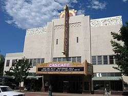 Cascade Theatre |
January 17, 2002 (#01001459) |
1731 Market St. 40°34′55″N 122°23′17″W |
Redding | |
| 3 | Cottonwood Historic District | 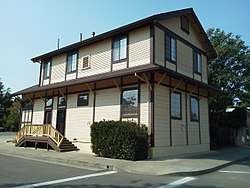 Cottonwood Historic District |
July 16, 1973 (#73000456) |
Off US 99 40°22′57″N 122°16′48″W |
Cottonwood | |
| 4 | Cow Creek Petroglyphs | November 5, 1971 (#71000195) |
Address Restricted |
Millville | ||
| 5 | Dersch-Taylor Petroglyphs | October 14, 1971 (#71000196) |
Address Restricted |
Millville | ||
| 6 | French Gulch Historic District | 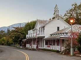 French Gulch Historic District |
March 24, 1972 (#72000257) |
Along both sides of French Gulch Rd. 40°41′35″N 122°38′12″W |
French Gulch | |
| 7 | Edward Frisbie House | 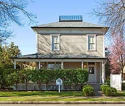 Edward Frisbie House |
March 29, 1990 (#90000550) |
1246 East St. 40°35′14″N 122°23′18″W |
Redding | |
| 8 | Gladstone Houses | November 29, 1995 (#95001374) |
12962-12964 Cline Gulch Rd. 40°43′16″N 122°34′52″W |
French Gulch | ||
| 9 | Horseshoe Lake Ranger Station | 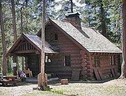 Horseshoe Lake Ranger Station |
May 5, 1978 (#78000292) |
North of Chester in Lassen Volcanic National Park 40°28′23″N 121°19′48″W |
Chester | |
| 10 | Lake Britton Archeological District | April 14, 1975 (#75000485) |
Address Restricted |
Burney | ||
| 11 | Lassen Volcanic National Park Highway Historic District |  Lassen Volcanic National Park Highway Historic District |
June 23, 2006 (#06000527) |
NPS Route 1, CA 89 40°30′02″N 121°30′38″W |
Mineral | |
| 12 | Loomis Visitor Center, Bldg. 43 | 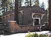 Loomis Visitor Center, Bldg. 43 |
February 25, 1975 (#75000177) |
Lassen Volcanic National Park 40°32′10″N 121°33′44″W |
Manzanita Lake | |
| 13 | Lorenz Hotel | 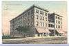 Lorenz Hotel |
March 19, 2012 (#12000129) |
1509 Yuba St. 40°34′58″N 122°23′31″W |
Redding | |
| 14 | Manzanita Lake Naturalist's Services Historic District | 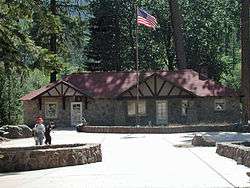 Manzanita Lake Naturalist's Services Historic District |
June 23, 2006 (#06000525) |
39489 Highway 44 40°32′08″N 121°33′51″W |
Shingletown | |
| 15 | Nobles Emigrant Trail | 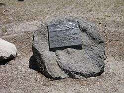 Nobles Emigrant Trail |
October 3, 1975 (#75000222) |
East of Shingletown in Lassen Volcanic National Park 40°32′50″N 121°25′29″W |
Shingletown | Extends into Lassen County. |
| 16 | Old City Hall Building | 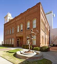 Old City Hall Building |
November 14, 1978 (#78000790) |
1313 Market St. 40°35′11″N 122°23′24″W |
Redding | |
| 17 | Olsen Petroglyphs | March 24, 1971 (#71000198) |
Address Restricted |
Redding | ||
| 18 | Phillips Brothers Mill | December 2, 2002 (#02001406) |
Approximately 30 miles (48 km) northeast of Redding 40°43′22″N 121°59′06″W |
Oak Run | ||
| 19 | Pine Street School | 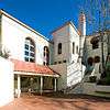 Pine Street School |
March 21, 1978 (#78000791) |
1135 Pine St. 40°35′21″N 122°23′20″W |
Redding | |
| 20 | Prospect Peak Fire Lookout | March 30, 1978 (#78000295) |
Northeast of Mineral 40°34′24″N 121°20′42″W |
Mineral | ||
| 21 | Reading Adobe Site |  Reading Adobe Site |
July 14, 1971 (#71000194) |
Adobe Lane, 5 miles (8.0 km) east of the center of Cottonwood 40°23′30″N 122°11′56″W |
Cottonwood | |
| 22 | Shasta State Historic Park | 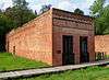 Shasta State Historic Park |
October 14, 1971 (#71000199) |
Highway 299 40°35′56″N 122°29′30″W |
Shasta | |
| 23 | Squaw Creek Archeological Site | September 3, 1981 (#81000179) |
Address Restricted |
Redding | ||
| 24 | Sulphur Creek Archeological District | April 14, 1980 (#80000370) |
Address Restricted |
Mill Creek | ||
| 25 | Summit Lake Ranger Station | 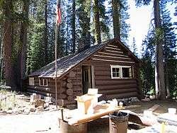 Summit Lake Ranger Station |
April 3, 1978 (#78000296) |
Northeast of Mineral in Lassen Volcanic National Park 40°29′54″N 121°25′37″W |
Mineral | |
| 26 | Swasey Discontiguous Archeological District | March 12, 2003 (#03000115) |
Address Restricted |
Redding | ||
| 27 | Tower House District | July 2, 1973 (#73000257) |
Whiskeytown National Recreation Area 40°39′46″N 122°38′05″W |
Whiskeytown | ||
| 28 | Tower House-Soo-Yeh-Choo-Pus | November 4, 1985 (#85003483) |
Address Restricted |
French Gulch | ||
| 29 | Twin Lakes Fire Tool Cache | October 25, 2016 (#16000745) |
Lassen Volcanic National Park 40°30′46″N 121°21′47″W |
Mineral vicinity |
gollark: … (!esowiki) WHY
gollark: Ah, ageist inequality …
gollark: Compile a language to Rust and then just use Rust Rust Rust ***RUST*** *praise rust* **Rust** **ruusususususususts** ***RUST*** *hail the overlord of languages* *rust*
gollark: *languages allowing correct, reliable programs are good
gollark: ```The loneliest is a.(Abs function)(returns the absolute value of 'a thought')Abs takes a thoughtIf a thought is greater than nothingGive back a thoughtElseGive back nothing without a thought(end Abs function)(Pow function)(returns 'all' raised to 'your base')Pow takes all and your baseIf your base is emptyGive back the loneliest (end if)If your base is less than nothingPut nothing without your base into your baseGive back the loneliest over Pow taking all, your base (end if)Put the loneliest into the onePut all into the magicWhile the one is smaller than your basePut all of the magic into the magicBuild the one up (end while)Give back the magic(end Pow function)(some constants for Sqrt function)The wing is strange.My song is knickknack. lumberjacksPut Pow taking my song, the wing into the dawnHalf is flummoxing. huzza(Sqrt function)(iterates until the estimate update is less than 'the dawn')Sqrt takes a mountainIf a mountain is nowhereGive back nothing (end if)Put a mountain into a molehillPut a molehill into the seaWhile Abs taking the sea is greater than the dawnPut a molehill into the seaPut Half of a molehill with Half of a mountain over a molehill into a molehillPut the sea without a molehill into the sea (end while)Give back a molehill(end Sqrt function)```A simple maths library.
See also
| Wikimedia Commons has media related to National Register of Historic Places in Shasta County, California. |
References
- The latitude and longitude information provided in this table was derived originally from the National Register Information System, which has been found to be fairly accurate for about 99% of listings. Some locations in this table may have been corrected to current GPS standards.
- "National Register of Historic Places: Weekly List Actions". National Park Service, United States Department of the Interior. Retrieved on August 14, 2020.
- Numbers represent an ordering by significant words. Various colorings, defined here, differentiate National Historic Landmarks and historic districts from other NRHP buildings, structures, sites or objects.
- "National Register Information System". National Register of Historic Places. National Park Service. July 9, 2010.
- The eight-digit number below each date is the number assigned to each location in the National Register Information System database, which can be viewed by clicking the number.
| Topics | |
|---|---|
| Lists by state |
|
| Lists by insular areas | |
| Lists by associated state | |
| Other areas | |
| Related | |
| |
Municipalities and communities of Shasta County, California, United States | ||
|---|---|---|
| Cities | Shasta County map | |
| CDPs | ||
| Unincorporated communities | ||
| Indian reservations | ||
| Ghost towns |
| |
| Footnotes | ‡This populated place also has portions in an adjacent county or counties | |
This article is issued from Wikipedia. The text is licensed under Creative Commons - Attribution - Sharealike. Additional terms may apply for the media files.