National Register of Historic Places listings in Meade County, South Dakota
This is a list of the National Register of Historic Places listings in Meade County, South Dakota.
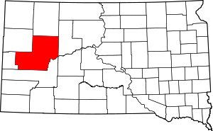
Location of Meade County in South Dakota
This is intended to be a complete list of the properties and districts on the National Register of Historic Places in Meade County, South Dakota, United States. The locations of National Register properties and districts for which the latitude and longitude coordinates are included below, may be seen in a map.[1]
There are 31 properties and districts listed on the National Register in the county, including 1 National Historic Landmark.
- This National Park Service list is complete through NPS recent listings posted August 14, 2020.[2]
Current listings
| [3] | Name on the Register[4] | Image | Date listed[5] | Location | City or town | Description |
|---|---|---|---|---|---|---|
| 1 | Archeological Site No. 39MD20 | August 6, 1993 (#93000798) |
Address Restricted |
Tilford | ||
| 2 | Archeological Site No. 39MD81 | April 14, 1994 (#93000818) |
Address Restricted |
Sturgis | ||
| 3 | Archeological Site No. 39MD82 | April 14, 1994 (#93000797) |
Address Restricted |
Sturgis | ||
| 4 | Joseph Baker House | April 30, 1986 (#86000942) |
County Road 19A Coordinates missing |
Hereford | ||
| 5 | L.L. Bartlett House | April 30, 1986 (#86000946) |
County Road 26 Coordinates missing |
Stoneville | ||
| 6 | Bear Butte | 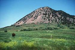 Bear Butte |
June 19, 1973 (#73001746) |
Northeast of Sturgis 44°28′25″N 103°25′33″W |
Sturgis | |
| 7 | Bethel Lutheran Church | April 30, 1986 (#86000941) |
Main and 5th Sts. 45°01′10″N 102°02′19″W |
Faith | ||
| 8 | Black Hawk Elementary School | April 30, 1986 (#86000939) |
Main and Elm Sts. 44°09′04″N 103°18′35″W |
Blackhawk | ||
| 9 | Black Hills National Cemetery | 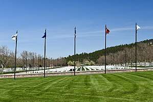 Black Hills National Cemetery |
May 17, 2016 (#16000258) |
20901 Pleasant Valley Dr. 44°22′11″N 103°28′28″W |
Sturgis | |
| 10 | Covered Wagon Resort | November 20, 2007 (#07001213) |
14189 County Road 79 44°13′01″N 103°22′23″W |
Piedmont | ||
| 11 | Erskine School | 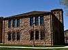 Erskine School |
August 16, 1984 (#84003354) |
Sherman St. 44°24′45″N 103°30′52″W |
Sturgis | |
| 12 | John and Coralin Evans Ranch | April 30, 1986 (#86000943) |
County Road 4 Coordinates missing |
Piedmont | ||
| 13 | Fort Meade National Historic District | 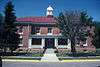 Fort Meade National Historic District |
May 22, 1973 (#73001747) |
East of Sturgis on Highway 34 44°24′46″N 103°28′22″W |
Sturgis | |
| 14 | Fort Meade Veterans Administration Hospital | May 29, 2018 (#100002467) |
113 Comanche Rd. 44°24′44″N 103°28′11″W |
Fort Meade | ||
| 15 | Frozenman Stage Station | June 18, 1992 (#92000691) |
Address Restricted |
Bison | ||
| 16 | Stephen and Maria Graf House | 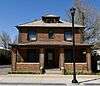 Stephen and Maria Graf House |
October 31, 2002 (#02001283) |
1233 Main St. 44°24′52″N 103°30′49″W |
Sturgis | |
| 17 | H O Ranch Log House | June 21, 1990 (#90000954) |
3 miles west of Marcus 44°39′49″N 102°20′10″W |
Marcus | ||
| 18 | Ole and Carris Johnson Ranch | April 30, 1986 (#86000938) |
County Road 7 Coordinates missing |
Blackhawk | ||
| 19 | John and Elsie McMillan House | 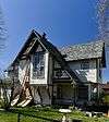 John and Elsie McMillan House |
October 30, 2015 (#15000765) |
1611 Davenport St. 44°24′30″N 103°30′29″W |
Sturgis | |
| 20 | Minneapolis Brewing Company Beer Warehouse | February 9, 2001 (#01000100) |
Highway 212 45°01′24″N 102°02′07″W |
Faith | ||
| 21 | Municipal Building-City Hall | June 22, 2000 (#00000722) |
206 Main St. 45°01′20″N 102°02′18″W |
Faith | Architect U.L. Freed. Now the Municipal Bar/Liquor Store. | |
| 22 | Elias B. Olsen Ranch | April 30, 1986 (#86000940) |
County Road 6 Coordinates missing |
Elm Springs | ||
| 23 | Jacob and Elizabeth Raskob Ranch | April 30, 1986 (#86000945) |
Highway 34 44°28′12″N 103°20′54″W |
Sturgis | ||
| 24 | South Dakota Dept. of Transportation Bridge No. 47-151-389 | December 9, 1993 (#93001263) |
Local road over Bear Butte Creek 44°28′33″N 103°15′58″W |
Sturgis | Replaced in 2010[6] | |
| 25 | Stevens Ranch | April 30, 1986 (#86000944) |
County Road 4 Coordinates missing |
Piedmont | ||
| 26 | Stomprude Trail Ruts | June 18, 1992 (#92000690) |
Address Restricted |
Bison | ||
| 27 | Sturgis Commercial Block | 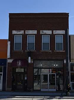 Sturgis Commercial Block |
June 20, 1975 (#75001719) |
1000-1028 Main St. 44°24′50″N 103°30′33″W |
Sturgis | |
| 28 | Sturgis High School | 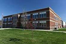 Sturgis High School |
August 16, 2000 (#00000998) |
1425 Cedar St. 44°24′35″N 103°31′16″W |
Sturgis | |
| 29 | Sturgis Water Works Company Supply Works Site | December 6, 2016 (#16000827) |
2835 Davenport St. 44°24′12″N 103°30′28″W |
Sturgis | ||
| 30 | Annie Tallent House | 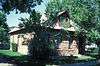 Annie Tallent House |
May 28, 1976 (#76001746) |
1603 Main St. 44°24′53″N 103°31′01″W |
Sturgis | |
| 31 | John G. Wenke House | 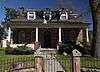 John G. Wenke House |
May 28, 1976 (#76001747) |
1340 Junction Ave. 44°24′39″N 103°30′30″W |
Sturgis |
Former listings
| [3] | Name on the Register | Image | Date listed | Date removed | Location | City or town | Summary |
|---|---|---|---|---|---|---|---|
| 1 | South Dakota Dept. of Transportation Bridge No. 47-215-363 | December 9, 1993 (#93001303) | December 15, 1999 | SD 34 over the Belle Fourche R. |
Sturgis vicinity | ||
| 2 | Poker Alice Tubbs House | June 5, 1975 (#75001720) | May 29, 1990 | N. Junction St. |
Sturgis |
gollark: Hmm, magical weight loss products WHEN?
gollark: You wouldn't become obese because you could just dump the energy into the gems.
gollark: High efficiency apiarization protocols.
gollark: Presumably they worked out how to make it draw energy from arbitrary chemical... energy... or something like that.
gollark: Of course.
See also
| Wikimedia Commons has media related to National Register of Historic Places in Meade County, South Dakota. |
References
- The latitude and longitude information provided in this table was derived originally from the National Register Information System, which has been found to be fairly accurate for about 99% of listings. Some locations in this table may have been corrected to current GPS standards.
- "National Register of Historic Places: Weekly List Actions". National Park Service, United States Department of the Interior. Retrieved on August 14, 2020.
- Numbers represent an ordering by significant words. Various colorings, defined here, differentiate National Historic Landmarks and historic districts from other NRHP buildings, structures, sites or objects.
- "National Register Information System". National Register of Historic Places. National Park Service. April 24, 2008.
- The eight-digit number below each date is the number assigned to each location in the National Register Information System database, which can be viewed by clicking the number.
| Topics | |
|---|---|
| Lists by state |
|
| Lists by insular areas | |
| Lists by associated state | |
| Other areas | |
| Related | |
| |
Municipalities and communities of Meade County, South Dakota, United States | ||
|---|---|---|
| Cities | Meade County map | |
| CDPs |
| |
| Former CDP | ||
| Unincorporated communities | ||
| Indian reservations | ||
| Ghost towns | ||
| Footnotes | ‡This populated place also has portions in an adjacent county or counties | |
This article is issued from Wikipedia. The text is licensed under Creative Commons - Attribution - Sharealike. Additional terms may apply for the media files.