National Register of Historic Places listings in Grand Isle County, Vermont
This is a list of the National Register of Historic Places listings in Grand Isle County, Vermont.
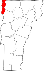
Location of Grand Isle County in Vermont
This is intended to be a complete list of the properties and districts on the National Register of Historic Places in Grand Isle County, Vermont, United States. Latitude and longitude coordinates are provided for many National Register properties and districts; these locations may be seen together in a map.[1]
There are 10 properties listed on the National Register in the county.
- This National Park Service list is complete through NPS recent listings posted August 14, 2020.[2]
| Addison - Bennington - Caledonia - Chittenden - Essex - Franklin - Grand Isle - Lamoille - Orange - Orleans - Rutland - Washington - Windham - Windsor |
Current listings
| [3] | Name on the Register[4] | Image | Date listed[5] | Location | City or town | Description |
|---|---|---|---|---|---|---|
| 1 | Congregational Church-Grand Isle | 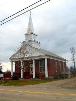 Congregational Church-Grand Isle |
March 2, 2001 (#01000224) |
12 Hyde Rd. 44°43′21″N 73°17′46″W |
Grand Isle | |
| 2 | Gordon-Center House | 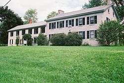 Gordon-Center House |
April 17, 1986 (#86000808) |
54 West Shore Rd. 44°41′19″N 73°20′50″W |
Grand Isle | |
| 3 | Grand Isle County Courthouse | 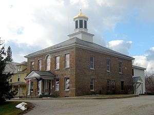 Grand Isle County Courthouse |
January 11, 1996 (#95001523) |
U.S. Route 2 44°49′07″N 73°17′24″W |
North Hero | |
| 4 | Ira Hill House | 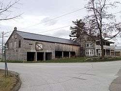 Ira Hill House |
November 13, 2003 (#03001164) |
2304 Main St. 44°52′40″N 73°20′21″W |
Isle La Motte | |
| 5 | Hyde Log Cabin | 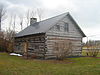 Hyde Log Cabin |
March 11, 1971 (#71000057) |
U.S. Route 2 44°43′34″N 73°17′32″W |
Grand Isle | |
| 6 | Methodist Episcopal Church of Isle La Motte | 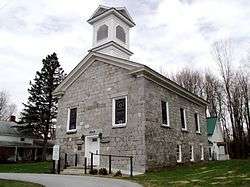 Methodist Episcopal Church of Isle La Motte |
March 2, 2001 (#01000223) |
67 Church St. 44°52′37″N 73°20′17″W |
Isle La Motte | |
| 7 | Rutland Railroad Pumping Station | 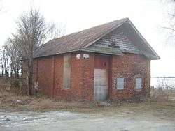 Rutland Railroad Pumping Station |
December 30, 1999 (#99001630) |
43 Lake St. 44°58′29″N 73°18′37″W |
Alburg | |
| 8 | South Hero Inn | 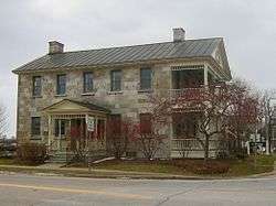 South Hero Inn |
April 16, 1975 (#75000141) |
South St. and U.S. Route 2 44°38′42″N 73°18′13″W |
South Hero | |
| 9 | South Stone School House | 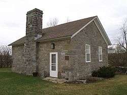 South Stone School House |
January 31, 1997 (#97000025) |
VT 129 at its junction with Quarry Rd. 44°51′07″N 73°20′40″W |
Isle La Motte | |
| 10 | U.S. Inspection Station-Alburg Springs, Vermont | 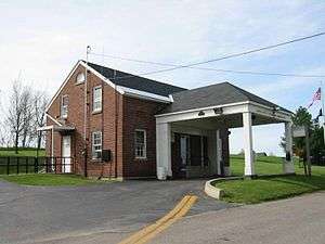 U.S. Inspection Station-Alburg Springs, Vermont |
September 10, 2014 (#14000607) |
303 Alburg Springs Rd. 45°00′46″N 73°12′45″W |
Alburg |
gollark: (Small = below 700M parameters)
gollark: I can run small GPT models for us.
gollark: Just have it arrange them into an overly large grid and make some of the connections skip over the empty cells.
gollark: In that case, we can probably apinate the topology somehow.
gollark: Anyway, it could be philosophically a "webring" but topologically have four direction buttons or something.
See also
| Wikimedia Commons has media related to National Register of Historic Places in Grand Isle County, Vermont. |
References
- The latitude and longitude information provided in this table was derived originally from the National Register Information System, which has been found to be fairly accurate for about 99% of listings. Some locations in this table may have been corrected to current GPS standards.
- "National Register of Historic Places: Weekly List Actions". National Park Service, United States Department of the Interior. Retrieved on August 14, 2020.
- Numbers represent an ordering by significant words. Various colorings, defined here, differentiate National Historic Landmarks and historic districts from other NRHP buildings, structures, sites or objects.
- "National Register Information System". National Register of Historic Places. National Park Service. April 24, 2008.
- The eight-digit number below each date is the number assigned to each location in the National Register Information System database, which can be viewed by clicking the number.
| Topics | |
|---|---|
| Lists by state |
|
| Lists by insular areas | |
| Lists by associated state | |
| Other areas | |
| Related | |
| |
Municipalities and communities of Grand Isle County, Vermont, United States | ||
|---|---|---|
Shire town: North Hero | ||
| Towns | Map of Vermont highlighting Grand Isle County | |
| Village | ||
This article is issued from Wikipedia. The text is licensed under Creative Commons - Attribution - Sharealike. Additional terms may apply for the media files.