National Register of Historic Places listings in Dorchester County, Maryland
This is a list of the National Register of Historic Places listings in Dorchester County, Maryland.
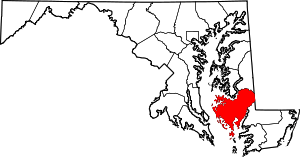
Location of Dorchester County in Maryland
This is intended to be a complete list of the properties and districts on the National Register of Historic Places in Dorchester County, Maryland, United States. Latitude and longitude coordinates are provided for many National Register properties and districts; these locations may be seen together in a map.[1]
There are 27 properties and districts listed on the National Register in the county.
| Allegany - Anne Arundel - Baltimore (city) - Baltimore County - Calvert - Caroline - Carroll - Cecil - Charles - Dorchester - Frederick - Garrett - Harford - Howard - Kent - Montgomery - Prince George's - Queen Anne's - Somerset - St. Mary's - Talbot - Washington - Wicomico - Worcester |
- This National Park Service list is complete through NPS recent listings posted August 14, 2020.[2]
Current listings
| [3] | Name on the Register[4] | Image | Date listed[5] | Location | City or town | Description |
|---|---|---|---|---|---|---|
| 1 | Bethlehem Methodist Episcopal Church |  Bethlehem Methodist Episcopal Church |
June 7, 1979 (#79001126) |
Hoopers Neck Rd. 38°28′56″N 76°18′58″W |
Taylors Island | |
| 2 | Brinsfield I Site |  Brinsfield I Site |
May 12, 1975 (#75000887) |
Address Restricted |
Cambridge | |
| 3 | Cambridge Historic District, Wards I and III | 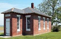 Cambridge Historic District, Wards I and III |
September 5, 1990 (#90001370) |
Roughly bounded by Glasgow, Glenburn, Poplar, Race, and Gay Sts. and the Choptank River 38°34′39″N 76°04′45″W |
Cambridge | |
| 4 | Christ Episcopal Church and Cemetery |  Christ Episcopal Church and Cemetery |
April 12, 1984 (#84001767) |
High St. 38°34′19″N 76°04′36″W |
Cambridge | |
| 5 | Dale's Right | April 3, 1979 (#79001125) |
South of Cambridge on Casson Neck Rd. 38°32′59″N 76°15′05″W |
Cambridge | ||
| 6 | Dorchester County Courthouse and Jail | 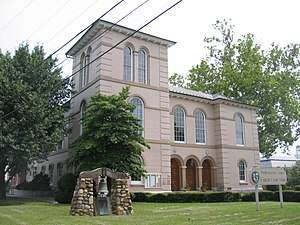 Dorchester County Courthouse and Jail |
December 16, 1982 (#82001591) |
206 High St. 38°34′18″N 76°04′34″W |
Cambridge | |
| 7 | East New Market Historic District |  East New Market Historic District |
October 1, 1975 (#75000889) |
Maryland Routes 14 and 16 38°35′53″N 75°55′25″W |
East New Market | |
| 8 | K. B. Fletcher Mill | K. B. Fletcher Mill |
December 14, 1978 (#78001456) |
Address Restricted |
East New Market | |
| 9 | Friendship Hall | _-_panoramio_(1).jpg) Friendship Hall |
October 18, 1973 (#73000915) |
Off Maryland Route 14 38°35′41″N 75°55′28″W |
East New Market | |
| 10 | Glasgow |  Glasgow |
October 8, 1976 (#76000991) |
1500 Hambrooks Boulevard 38°34′58″N 76°05′08″W |
Cambridge | |
| 11 | Glen Oak Hotel | 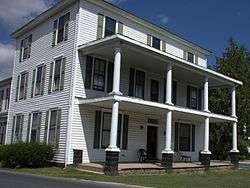 Glen Oak Hotel |
September 8, 1983 (#83002947) |
201 Academy St. 38°38′07″N 75°51′54″W |
Hurlock | |
| 12 | Goldsborough House |  Goldsborough House |
December 29, 1988 (#88003062) |
200 High St. 38°34′21″N 76°04′33″W |
Cambridge | |
| 13 | Grace Episcopal Church Complex | 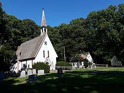 Grace Episcopal Church Complex |
July 24, 1979 (#79001127) |
Hooper Neck Rd. 38°28′15″N 76°18′32″W |
Taylors Island | |
| 14 | Handsell | 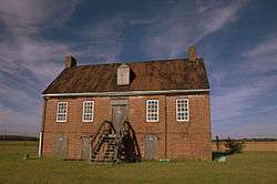 Handsell |
March 26, 2008 (#08000216) |
4835 Vienna Rhodesdale Rd. 38°30′39″N 75°48′44″W |
Vienna | |
| 15 | Hooper Island Light Station | 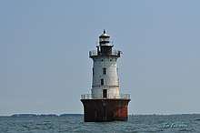 Hooper Island Light Station |
December 2, 2002 (#02001426) |
Approximately 5 miles south of Cove Pt 38°15′22″N 76°15′00″W |
Hoopersville | |
| 16 | Hughes A.M.E. Chapel |  Hughes A.M.E. Chapel |
June 29, 2018 (#100002630) |
4201 Maple Dam Rd. 38°27′01″N 76°04′18″W |
Cambridge vicinity | |
| 17 | LaGrange | 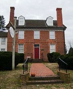 LaGrange |
January 24, 1980 (#80001809) |
904 LaGrange Ave. 38°33′59″N 76°03′36″W |
Cambridge | |
| 18 | Annie Oakley House |  Annie Oakley House |
May 7, 1996 (#96000469) |
28 Bellevue Ave. 38°35′22″N 76°05′23″W |
Cambridge | |
| 19 | PATRICIA (log canoe) | September 18, 1985 (#85002246) |
903 Roslyn Ave. 38°33′53″N 76°03′41″W |
Cambridge | ||
| 20 | Pine Street Neighborhood Historic District |  Pine Street Neighborhood Historic District |
November 28, 2012 (#12000976) |
High, Pine, & Washington Sts. 38°33′58″N 76°04′56″W |
Cambridge | |
| 21 | Rehoboth | 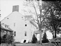 Rehoboth |
November 9, 1972 (#72000577) |
Western side of Punkum Rd. 38°35′14″N 75°47′48″W |
Eldorado | |
| 22 | Ridgeton Farm | .jpg) Ridgeton Farm |
October 5, 1977 (#77000694) |
Southwest of Taylor Island on Bay Shore Rd. 38°27′39″N 76°18′24″W |
Taylors Island | |
| 23 | Rock Methodist Episcopal Church | .jpg) Rock Methodist Episcopal Church |
May 28, 2014 (#13000968) |
2403 MD 16 38°32′41″N 76°06′10″W |
Cambridge | |
| 24 | Stanley Institute | 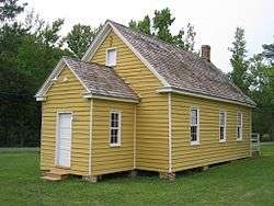 Stanley Institute |
September 11, 1975 (#75000888) |
South of Cambridge on Maryland Route 16 38°32′42″N 76°06′27″W |
Cambridge | |
| 25 | Sycamore Cottage | 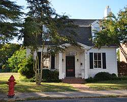 Sycamore Cottage |
March 30, 1988 (#88000231) |
417 High St. 38°34′12″N 76°04′46″W |
Cambridge | |
| 26 | Willin Village Archeological Site | Willin Village Archeological Site |
May 12, 1975 (#75000890) |
Address Restricted |
Eldorado | |
| 27 | Yarmouth | March 29, 1978 (#78001455) |
Southeast of Cambridge on Bestpitch Ferry Rd. 38°26′12″N 76°00′10″W |
Cambridge |
gollark: osmarks internet radio™ streams at 15.625kBHz.
gollark: Millibytes per second?
gollark: Technically, any "per second" can be replaced with "Hertz".
gollark: Or, more commonly, k🐝Hz.
gollark: k🐝ps
See also
| Wikimedia Commons has media related to National Register of Historic Places in Dorchester County, Maryland. |
References
- The latitude and longitude information provided in this table was derived originally from the National Register Information System, which has been found to be fairly accurate for about 99% of listings. Some locations in this table may have been corrected to current GPS standards.
- "National Register of Historic Places: Weekly List Actions". National Park Service, United States Department of the Interior. Retrieved on August 14, 2020.
- Numbers represent an ordering by significant words. Various colorings, defined here, differentiate National Historic Landmarks and historic districts from other NRHP buildings, structures, sites or objects.
- "National Register Information System". National Register of Historic Places. National Park Service. April 24, 2008.
- The eight-digit number below each date is the number assigned to each location in the National Register Information System database, which can be viewed by clicking the number.
| Topics |  | |
|---|---|---|
| Lists by county | ||
| Lists by city | ||
| Other lists | ||
| ||
Municipalities and communities of Dorchester County, Maryland, United States | ||
|---|---|---|
| City | | |
| Towns | ||
| CDP | ||
| Other communities | ||
| Footnotes | ‡This populated place also has portions in an adjacent county or counties | |
This article is issued from Wikipedia. The text is licensed under Creative Commons - Attribution - Sharealike. Additional terms may apply for the media files.