National Register of Historic Places listings in Codington County, South Dakota
This is a list of the National Register of Historic Places listings in Codington County, South Dakota.
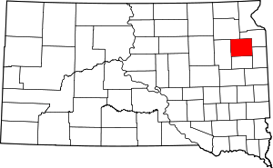
Location of Codington County in South Dakota
This is intended to be a complete list of the properties and districts on the National Register of Historic Places in Codington County, South Dakota, United States. The locations of National Register properties and districts for which the latitude and longitude coordinates are included below, may be seen in a map.[1]
There are 43 properties and districts listed on the National Register in the county. One property that was once listed on the Register has been removed.
- This National Park Service list is complete through NPS recent listings posted August 14, 2020.[2]
Current listings
| [3] | Name on the Register[4] | Image | Date listed[5] | Location | City or town | Description |
|---|---|---|---|---|---|---|
| 1 | E.C. Adams House | January 3, 1989 (#88003032) |
604 N. Maple 44°54′30″N 97°06′39″W |
Watertown | ||
| 2 | Barr Farmstead | August 4, 2005 (#05000831) |
15539 444th Ave. 45°08′00″N 97°19′55″W |
Florence | ||
| 3 | Beskow Barn | October 24, 2003 (#03001072) |
15689 456th Ave. 45°06′33″N 97°05′13″W |
South Shore | ||
| 4 | Carnegie Free Public Library |  Carnegie Free Public Library |
June 18, 1976 (#76001724) |
27 1st Ave., SE. 44°53′57″N 97°06′47″W |
Watertown | |
| 5 | Benjamin H. Cartford House | January 3, 1989 (#88003025) |
803 N. Maple 44°54′37″N 97°06′40″W |
Watertown | ||
| 6 | Citizens State Bank of Henry | 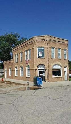 Citizens State Bank of Henry |
November 7, 1997 (#97001391) |
Junction of Main and 2nd Sts. 44°52′41″N 97°28′06″W |
Henry | |
| 7 | Codington County Courthouse |  Codington County Courthouse |
July 24, 1978 (#78002545) |
1st Ave., SE. 44°53′55″N 97°06′51″W |
Watertown | |
| 8 | Amy A. Davis House | 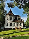 Amy A. Davis House |
January 3, 1989 (#88003030) |
20 4th Ave., NW. 44°54′21″N 97°06′55″W |
Watertown | |
| 9 | Curt E. DeGraff House | 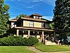 Curt E. DeGraff House |
January 3, 1989 (#88003033) |
603 N. Park 44°54′30″N 97°06′52″W |
Watertown | |
| 10 | Corson Emminger Round Barn | 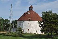 Corson Emminger Round Barn |
March 30, 1978 (#78002546) |
South of Watertown on U.S. Route 81 44°51′41″N 97°06′34″W |
Watertown | Tall round barn built by farmer Corson Emminger during 1909-10, made of concrete blocks with a two-tier roof and a cupola |
| 11 | Evangelical United Brethren Church |  Evangelical United Brethren Church |
January 3, 1989 (#88003026) |
409 N. Maple 44°54′22″N 97°06′41″W |
Watertown | |
| 12 | James W. Ferris House | 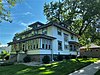 James W. Ferris House |
January 3, 1989 (#88003034) |
619 N. Park 44°54′31″N 97°06′52″W |
Watertown | |
| 13 | Florence Methodist Church | June 28, 1991 (#91000848) |
Junction of 5th St. and Dolly Ave. 45°03′20″N 97°19′46″W |
Florence | ||
| 14 | C.E. and Bertha Fowler House | 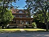 C.E. and Bertha Fowler House |
February 9, 2001 (#01000096) |
316 1st Ave., SE. 44°53′53″N 97°06′34″W |
Watertown | |
| 15 | Dr. H.M. Freeburg House | 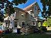 Dr. H.M. Freeburg House |
January 3, 1989 (#88003035) |
501 N. Park 44°54′26″N 97°06′52″W |
Watertown | |
| 16 | A.C. Gilruth House | 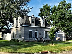 A.C. Gilruth House |
January 3, 1989 (#88003031) |
218 2nd Ave., NE. 44°54′14″N 97°06′31″W |
Watertown | |
| 17 | Goodhue Lutheran Church | July 17, 1996 (#96000745) |
15555 441st Ave. 45°07′47″N 97°23′33″W |
Florence | ||
| 18 | Nels M. Hanson Farmstead | July 13, 1989 (#89000831) |
4 miles (6.4 km) north of Henry 44°57′20″N 97°27′06″W |
Henry | ||
| 19 | John B. Hanten House | 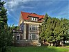 John B. Hanten House |
January 26, 1990 (#89002337) |
518 E. Kemp Ave. 44°53′54″N 97°06′19″W |
Watertown | |
| 20 | Dr. Harry Henningson House | 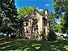 Dr. Harry Henningson House |
January 3, 1989 (#88003036) |
802 1st St., NW. 44°54′37″N 97°06′55″W |
Watertown | |
| 21 | Holy Rosary Church | June 6, 1986 (#86001227) |
Minnesota Ave. 44°53′35″N 96°55′01″W |
Kranzburg | ||
| 22 | A. Einar Johnson House | 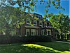 A. Einar Johnson House |
January 3, 1989 (#88003029) |
803 1st St., NW. 44°54′37″N 97°06′57″W |
Watertown | |
| 23 | Mabel and David Jones House | November 8, 2001 (#01001221) |
425 N. Park 44°54′23″N 97°06′51″W |
Watertown | ||
| 24 | Kemp Avenue Bridge | 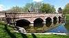 Kemp Avenue Bridge |
December 9, 1993 (#93001264) |
Kemp Ave. over the Big Sioux River 44°54′10″N 97°07′33″W |
Watertown | |
| 25 | Kranzburg School District No. 5 | June 28, 1991 (#91000847) |
Hasting St. 44°53′33″N 96°55′07″W |
Kranzburg | ||
| 26 | Mathiesen House | 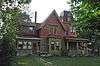 Mathiesen House |
February 1, 1982 (#82003923) |
914 N. Maple 44°54′42″N 97°06′38″W |
Watertown | |
| 27 | Peter Mauseth House | January 3, 1989 (#88003028) |
703 N. Maple 44°54′32″N 97°06′41″W |
Watertown | ||
| 28 | Andrew and Lulu Melham House | July 28, 2011 (#11000485) |
721 1st. St., NW 44°54′33″N 97°06′56″W |
Watertown | North End Neighborhood MPS | |
| 29 | Mellette House | 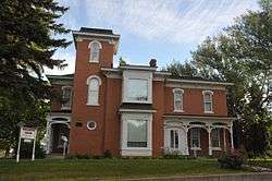 Mellette House |
August 13, 1976 (#76001725) |
421 5th Ave., NW. 44°54′26″N 97°07′16″W |
Watertown | |
| 30 | Minneapolis and St. Louis Railroad Depot | 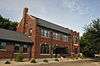 Minneapolis and St. Louis Railroad Depot |
October 31, 1985 (#85003477) |
168 N. Broadway 44°54′12″N 97°06′43″W |
Watertown | |
| 31 | Mount Hope Cemetery Mausoleum | 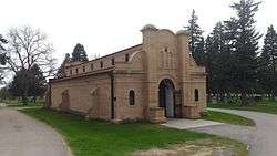 Mount Hope Cemetery Mausoleum |
August 13, 1986 (#86001500) |
Mt. Hope Cemetery off U.S. Route 81 44°54′59″N 97°05′56″W |
Watertown | |
| 32 | Olive Place | May 23, 1978 (#78002547) |
North of Watertown off U.S. Route 81 44°56′00″N 97°06′28″W |
Watertown | ||
| 33 | Puhlman Farm | October 24, 2003 (#03001075) |
44350 176th St. 44°50′08″N 97°20′28″W |
Hazel | ||
| 34 | Reeve's Resort | October 19, 1989 (#89001726) |
6 miles (9.7 km) south of Florence 44°58′41″N 97°21′18″W |
Florence | ||
| 35 | Nicholas T. Ries Farmstead | February 11, 1988 (#88000047) |
Off Codington County Highway 3 44°51′43″N 96°55′35″W |
Kranzburg | ||
| 36 | Gen. Mark W. Sheafe House | 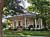 Gen. Mark W. Sheafe House |
February 26, 1987 (#87000222) |
57 4th Ave., NW. 44°54′24″N 97°06′51″W |
Watertown | |
| 37 | South Dakota Dept. of Transportation Bridge No. 15-210-136 | December 9, 1993 (#93001265) |
Local road over an unnamed creek 44°57′11″N 97°03′55″W |
Watertown | ||
| 38 | Dr. Tarbell House | 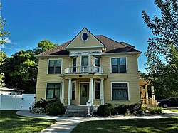 Dr. Tarbell House |
June 6, 2001 (#01000634) |
304 2nd Ave., SE. 44°53′49″N 97°06′36″W |
Watertown | |
| 39 | Watertown Commercial Historic District | 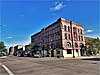 Watertown Commercial Historic District |
July 13, 1989 (#89000834) |
Roughly bounded by 1st Ave., N., 3rd St., E., 2nd Ave., S., and 1st St., W. 44°54′00″N 97°06′49″W |
Watertown | |
| 40 | Watertown Post Office | 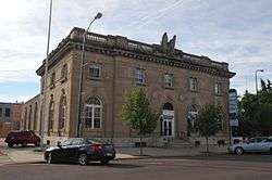 Watertown Post Office |
December 12, 1976 (#76001726) |
26 S. Broadway 44°53′58″N 97°06′51″W |
Watertown | |
| 41 | Watertown Stadium | Watertown Stadium |
July 5, 2000 (#00000721) |
1600 W. Kemp Ave. 44°54′07″N 97°08′22″W |
Watertown | |
| 42 | Walter Willson House | 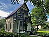 Walter Willson House |
January 3, 1989 (#88003027) |
702 2nd St., NE. 44°54′33″N 97°06′33″W |
Watertown | |
| 43 | Zech Farmstead | March 31, 2005 (#04001360) |
16676 456th Ave. 44°58′04″N 97°05′05″W |
Watertown |
Former listings
| [3] | Name on the Register | Image | Date listed | Date removed | Location | City or town | Summary |
|---|---|---|---|---|---|---|---|
| 1 | Appleby Atlas Elevator | June 21, 1990 (#90000957) | August 1, 2012 | 6 miles (9.7 km) south of the junction of Interstate 29 and U.S. Route 212 44°48′56″N 97°02′59″W |
Watertown | Torn down[6] | |
| 2 | Halse Halfway House | June 5, 1975 (#75001715) | June 9, 1987 | 6 mi. N of Florence |
Florence vicinity | ||
| 2 | Larson Bridge | December 9, 1993 (#93001266) | December 15, 1999 | Local rd. over Willow Cr. |
Watertown vicinity | ||
| 3 | Watertown Light and Power Company Plant | July 30, 1989 (#89000830) | May 1, 2001 | 524 W. Kemp Street |
Watertown |
gollark: Macs are definitely not that good. MacBooks have horrendous thermal throttling issues because they add moar coar and stuff without improving already inadequate fanless cooling.
gollark: You could use base64 with - and _ instead of + and /.
gollark: Just name your variables random 10-char alphabetical character sequences.
gollark: I would do a line as three blitable strings.
gollark: But if you want to iterate through, say, everything with depth 4, in order?
See also
| Wikimedia Commons has media related to National Register of Historic Places in Codington County, South Dakota. |
References
- The latitude and longitude information provided in this table was derived originally from the National Register Information System, which has been found to be fairly accurate for about 99% of listings. Some locations in this table may have been corrected to current GPS standards.
- "National Register of Historic Places: Weekly List Actions". National Park Service, United States Department of the Interior. Retrieved on August 14, 2020.
- Numbers represent an ordering by significant words. Various colorings, defined here, differentiate National Historic Landmarks and historic districts from other NRHP buildings, structures, sites or objects.
- "National Register Information System". National Register of Historic Places. National Park Service. April 24, 2008.
- The eight-digit number below each date is the number assigned to each location in the National Register Information System database, which can be viewed by clicking the number.
- Preserve South Dakota
| Topics | |
|---|---|
| Lists by state |
|
| Lists by insular areas | |
| Lists by associated state | |
| Other areas | |
| Related | |
| |
Municipalities and communities of Codington County, South Dakota, United States | ||
|---|---|---|
| City | | |
| Towns | ||
| CDP | ||
| Unincorporated communities | ||
| Indian reservation | ||
| Footnotes | ‡This populated place also has portions in an adjacent county or counties | |
This article is issued from Wikipedia. The text is licensed under Creative Commons - Attribution - Sharealike. Additional terms may apply for the media files.