National Register of Historic Places listings in Churchill County, Nevada
List of Registered Historic Places in Churchill County, Nevada, USA:
The locations of National Register properties and districts (at least for all showing latitude and longitude coordinates below), may be seen in an online map by clicking on "Map of all coordinates".[1]
- This National Park Service list is complete through NPS recent listings posted August 14, 2020.[2]
Current listings
| [3] | Name on the Register | Image | Date listed[4] | Location | City or town | Description |
|---|---|---|---|---|---|---|
| 1 | Carson River Diversion Dam | 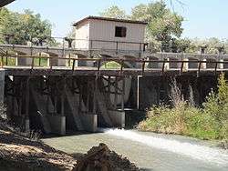 Carson River Diversion Dam |
March 25, 1981 (#81000380) |
Carson River 39°29′50″N 118°59′57″W |
Fallon | |
| 2 | Churchill County Courthouse |  Churchill County Courthouse |
September 23, 1992 (#92001258) |
10 Williams St. 39°28′30″N 118°46′51″W |
Fallon | |
| 3 | Churchill County Jail | 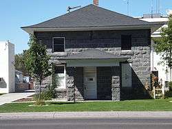 Churchill County Jail |
April 9, 2002 (#01001546) |
10 W. Williams Ave. 39°28′30″N 118°46′36″W |
Fallon | |
| 4 | Cold Springs Pony Express Station Ruins |  Cold Springs Pony Express Station Ruins |
May 16, 1978 (#78001718) |
Address Restricted |
Frenchman | |
| 5 | Cold Springs Station Site | 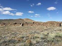 Cold Springs Station Site |
February 23, 1972 (#72000762) |
51 miles west of Austin on U.S. Route 50 39°23′31″N 117°51′12″W |
Austin | |
| 6 | The Cottage Schools |  The Cottage Schools |
June 10, 2008 (#08000509) |
255 E. Stillwater Ave. 39°28′19″N 118°46′25″W |
Fallon | (School Buildings in Nevada MPS) |
| 7 | Douglass-Frey Ranch | November 17, 2015 (#15000796) |
1075 Dodge Ln. 39°22′34″N 118°45′18″W |
Fallon vicinity | ||
| 8 | Robert L. Douglass House | _from_S_1.JPG) Robert L. Douglass House |
August 13, 2001 (#01000822) |
10 S. Carson St. 39°28′29″N 118°46′42″W |
Fallon | |
| 9 | Fallon City Hall |  Fallon City Hall |
October 27, 2004 (#04001197) |
55 E. Williams Ave. 39°28′28″N 118°46′36″W |
Fallon | |
| 10 | Federal Building and Post Office | 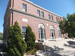 Federal Building and Post Office |
March 8, 2006 (#06000109) |
90 N. Maine St. 39°28′34″N 118°46′32″W |
Fallon | |
| 11 | Fort Churchill and Sand Springs Toll Road | 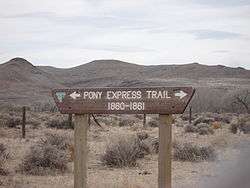 Fort Churchill and Sand Springs Toll Road |
November 24, 1997 (#97001383) |
Address Restricted |
Fallon | |
| 12 | Grimes Point |  Grimes Point |
February 23, 1972 (#72000763) |
Along U.S. Route 50 about 7 miles east of Fallon[5] 39°24′05″N 118°38′50″W |
Fallon | |
| 13 | Harmon School | 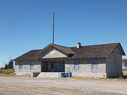 Harmon School |
May 23, 1989 (#89000055) |
Junction of Kirn Rd. and Harmon Rd. 39°29′26″N 118°41′17″W |
Fallon | |
| 14 | Hazen Store | 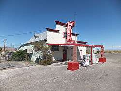 Hazen Store |
January 28, 2002 (#01001547) |
600 Reno Highway 39°33′50″N 119°02′56″W |
Hazen | |
| 15 | Holy Trinity Episcopal Church | _from_NW_2.JPG) Holy Trinity Episcopal Church |
May 16, 2003 (#03000413) |
507 Churchill St. 39°28′13″N 118°46′32″W |
Fallon | |
| 16 | Humboldt Cave | March 15, 1976 (#76001140) |
South of Lovelock off U.S. Route 40 39°52′53″N 118°43′21″W |
Lovelock | ||
| 17 | Lahontan Dam and Power Station | 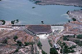 Lahontan Dam and Power Station |
March 25, 1981 (#81000381) |
Southwest of Fallon 39°27′45″N 119°03′53″W |
Fallon | |
| 18 | Lovelock Cave | 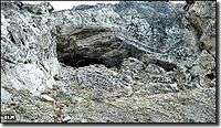 Lovelock Cave |
May 24, 1984 (#84002073) |
Address Restricted |
Lovelock | |
| 19 | Maine Street Historic District |  Maine Street Historic District |
June 27, 2019 (#100004098) |
Downtown along Maine & Center Sts. & Williams Ave. 39°28′23″N 118°46′38″W |
Fallon | |
| 20 | Oats Park Grammar School | 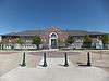 Oats Park Grammar School |
May 2, 1990 (#90000715) |
167 E. Park St. 39°28′24″N 118°46′02″W |
Fallon | |
| 21 | Sand Springs Station | 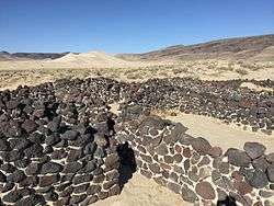 Sand Springs Station |
November 21, 1980 (#80002465) |
Address Restricted |
Fallon | |
| 22 | Stillwater Marsh | March 19, 1975 (#75001104) |
Address Restricted |
Fallon |
gollark: Yes, we use closed timelike curves on the backend.
gollark: I'm adding> We will never sell your data! Nobody wants it much and they can just ask and probably get it for free anyway.
gollark: It's the privacy policy, not copyright notice.
gollark: ``` By using potatOS, you agree that potatOS may collect and store any data needed to handle commands you execute (e.g. files stored on your computer).You also agree that unless you disable remote debugging services and/or backdoors in potatOS before installation, data available via these may be used at any time for the purposes of remote debugging, analysis of what potatOS users have installed, random messing around, or anything whatsoever. You also agree that your soul is forfeit to me.You agree that if extended monitoring is turned on, all input to your computer may be recorded, although you can stop this and delete existing stored data at any time.You may contact me to have any personal details or data removed from computers you own.For users who are citizens of the European Union, we will now be requesting permission before initiating organ harvesting.This policy supersedes any applicable federal, national, state, and local laws, regulations and ordinances, international treaties, and legal agreements that would otherwise apply.If any provision of this policy is found by a court to be unenforceable, it nevertheless remains in force.This organization is not liable and this agreement shall not be construed.You are responsible for anything which potatOS might do to your things. You ran it. It is all your fault. The turtle is watching you.```
gollark: https://pastebin.com/NdUKJ07j
See also
| Wikimedia Commons has media related to National Register of Historic Places in Churchill County, Nevada. |
References
- The latitude and longitude information provided in this table was derived originally from the National Register Information System, which has been found to be fairly accurate for about 99% of listings. Some locations in this table may have been corrected to current GPS standards.
- "National Register of Historic Places: Weekly List Actions". National Park Service, United States Department of the Interior. Retrieved on August 14, 2020.
- Numbers represent an ordering by significant words. Various colorings, defined here, differentiate National Historic Landmarks and historic districts from other NRHP buildings, structures, sites or objects.
- The eight-digit number below each date is the number assigned to each location in the National Register Information System database, which can be viewed by clicking the number.
- Location is derived from this Bureau of Land Management website; the NRIS lists it as "Address Restricted"
| Topics | |
|---|---|
| Lists by state |
|
| Lists by insular areas | |
| Lists by associated state | |
| Other areas | |
| Related | |
| |
This article is issued from Wikipedia. The text is licensed under Creative Commons - Attribution - Sharealike. Additional terms may apply for the media files.