Nasirabad (Hunza)
Nasirabad (Urdu: ناصر آباد) is a town located in the Hunza District of Gilgit-Baltistan, Pakistan.
Nasirabad ناصر آباد | |
|---|---|
Town | |
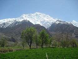 The Nasirabad Hunza valley | |
 Nasirabad | |
| Coordinates: 36.263844°N 74.525956°E | |
| Country | Pakistan |
| Population (2017) | |
| • Total | 6,000 |
Geography
Nasirabad is located in Gilgit-Baltistan and bordered to the south by the Hunza River. The Karakoram Highway is the main commercial road, containing multiple businesses including hotels, hostels, cafes, and stores.
Former names
Nasirabad was known as Hayul Dass during the Rono age. It was later known as Manishmal, a Hindi word for "a fertile place with great prosperity". Later still it was known as "Hini", derived from "Hin", which means "snow" in the Shina language.[1]
History
The earliest known history of Nasirabad dates back to the Rono people, who flourished across the Hunza region. The Rono emerged and flourished before the early-16th-century arrival of the forefathers of the current tribes in the settlement, such as the Tartay and Doodiye.[1]
Gallery
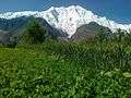 Nasirabad
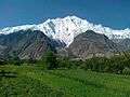
- Nasirabad
 Nasirabad
References
- Hunzai, Sardar Khan. Introduction To The Lower Hunza, Shinaki Area. Year not available.