Namur Province
Namur (French: [namyʁ]; Dutch: Namen [ˈnaːmə(n)] (![]()
Namur | |
|---|---|
 Flag .svg.png) Coat of arms | |
 | |
| Coordinates: 50°28′N 04°51′E | |
| Country | |
| Region | |
| Capital | Namur |
| Government | |
| • Governor | Denis Mathen |
| Area | |
| • Total | 3,675 km2 (1,419 sq mi) |
| Population (1 January 2019)[2] | |
| • Total | 494,325 |
| • Density | 135/km2 (350/sq mi) |
| HDI (2017) | 0.886[3] very high · 9th |
| Website | Official site |
Subdivisions

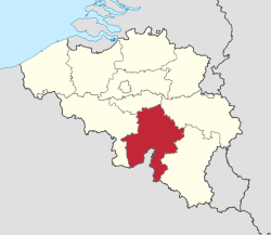
It has an area of 3,675 square kilometres (1,419 sq mi) and is divided into three administrative districts (arrondissements in French) containing a total of 38 municipalities (communes in French).
| Map no. | Municipality | Arrondissement |
|---|---|---|
| 1 | Andenne | Namur |
| 2 | Anhée | Dinant |
| 3 | Assesse | Namur |
| 4 | Beauraing | Dinant |
| 5 | Bièvre | Dinant |
| 6 | Cerfontaine | Philippeville |
| 7 | Ciney | Dinant |
| 8 | Couvin | Philippeville |
| 9 | Dinant | Dinant |
| 10 | Doische | Philippeville |
| 11 | Éghezée | Namur |
| 12 | Fernelmont | Namur |
| 13 | Floreffe | Namur |
| 14 | Florennes | Philippeville |
| 15 | Fosses-la-Ville | Namur |
| 16 | Gedinne | Dinant |
| 17 | Gembloux | Namur |
| 18 | Gesves | Namur |
| 19 | Hamois | Dinant |
| 20 | Hastière | Dinant |
| 21 | Havelange | Dinant |
| 22 | Houyet | Dinant |
| 23 | Jemeppe-sur-Sambre | Namur |
| 24 | La Bruyère | Namur |
| 25 | Mettet | Namur |
| 26 | Namur | Namur |
| 27 | Ohey | Namur |
| 28 | Onhaye | Dinant |
| 29 | Philippeville | Philippeville |
| 30 | Profondeville | Namur |
| 31 | Rochefort | Dinant |
| 32 | Sambreville | Namur |
| 33 | Sombreffe | Namur |
| 34 | Somme-Leuze | Dinant |
| 35 | Viroinval | Philippeville |
| 36 | Vresse-sur-Semois | Dinant |
| 37 | Walcourt | Philippeville |
| 38 | Yvoir | Dinant |
Economy
The Gross domestic product (GDP) of the province was 13.5 billion € in 2018, accounting for 2.9% of Belgiums economic output. GDP per capita adjusted for purchasing power was 24,000 € or 80% of the EU27 average in the same year. GDP per person employed was 104% of the EU27 average.[5]
List of Governors
- 1830–1834: Goswin de Stassart (Liberal)
- 1834–1840: Joseph Lebeau (Liberal)
- 1840–1847: Edouard d'Huart (Liberal)
- 1887–1848: Adolphe de Vrière (Liberal)
- 1848–1851: François Pirson (Liberal)
- 1853–1875: Charles de Baillet (Catholic Party)
- 1876–1877: D. de Mevius
- 1877–1881: Albert de Beauffort (Catholic Party)
- 1881–1882: Léon Pety de Thozée (Liberal)
- 1882–1884: Auguste Vergote
- 1884–1914: Charles de Montpellier de Vedrin
- 1919–1937: Pierre de Gaiffier d'Hestroy
- 1937–1944: François Bovesse (Liberal)
- 1945–1968: Robert Gruslin
- 1968–1977: René Close (PS)
- 1977–1980: Pierre Falize (PS)
- 1980–1987: Emile Lacroix
- 1987–1994: Emile Wauthy (PSC)
- 1994–2007: Amand Dalem (PSC)
- 2007–present: Denis Mathen (MR)
Twinning
The Province of Namur is twinned with:[6]


See also
- List of rulers of Namur
References
- https://bestat.statbel.fgov.be/bestat/crosstable.xhtml?view=90c1e218-dc4f-4827-824d-9b25abfefe59
- https://statbel.fgov.be/nl/themas/bevolking/structuur-van-de-bevolking
- "Sub-national HDI - Area Database - Global Data Lab". hdi.globaldatalab.org. Retrieved 2018-09-13.
- https://statbel.fgov.be/nl/themas/bevolking/structuur-van-de-bevolking
- "Regional GDP per capita ranged from 30% to 263% of the EU average in 2018". Eurostat.
- "Service des relations extérieures et internationales". province.namur.be (in French). Retrieved 2019-06-22.
External links
| Wikimedia Commons has media related to Namur (province). |
- Province de Namur's official website
- . Encyclopædia Britannica (11th ed.). 1911.
