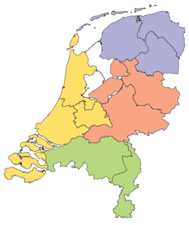
NUTS statistical regions of the Netherlands
In the NUTS (Nomenclature of Territorial Units for Statistics) codes of the 'Netherlands (NL), the three levels are:
| Level | Subdivisions | # |
|---|---|---|
| NUTS 1 | Lands (Landsdelen) | 4 |
| NUTS 2 | Provinces (Provincies) | 12 |
| NUTS 3 | COROP regions (COROP regio's) | 40 |

NUTS 1 - 4 Landsdelen
NUTS codes
| NUTS 1 | Code | NUTS 2 | Code | NUTS 3 | Code |
|---|---|---|---|---|---|
| North Netherlands | NL1 | Groningen | NL11 | East Groningen | NL111 |
| Delfzijl and surroundings | NL112 | ||||
| Rest of Groningen | NL113 | ||||
| Friesland | NL12 | North Friesland | NL121 | ||
| South West Friesland | NL122 | ||||
| South East Friesland | NL123 | ||||
| Drenthe | NL13 | North Drenthe | NL131 | ||
| South East Drenthe | NL132 | ||||
| South West Drenthe | NL133 | ||||
| East Netherlands | NL2 | Overijssel | NL21 | North Overijssel | NL211 |
| South West Overijssel | NL212 | ||||
| Twente | NL213 | ||||
| Gelderland | NL22 | Veluwe | NL221 | ||
| South West Gelderland | NL224 | ||||
| Achterhoek | NL225 | ||||
| Arnhem & Nijmegen | NL226 | ||||
| Flevoland | NL23 | Flevoland | NL230 | ||
| West Netherlands | NL3 | Utrecht | NL31 | Utrecht | NL310 |
| North Holland | NL32 | Kop van North Holland | NL321 | ||
| Alkmaar and surroundings | NL322 | ||||
| IJmond | NL323 | ||||
| Haarlem agglomeration | NL324 | ||||
| Zaanstreek | NL325 | ||||
| Greater Amsterdam | NL329 | ||||
| Het Gooi and Vechtstreek | NL327 | ||||
| South Holland | NL33 | Leiden and Bollenstreek | NL331 | ||
| The Hague | NL332 | ||||
| Delft and Westland | NL333 | ||||
| East South Holland | NL334 | ||||
| Rijnmond | NL335 | ||||
| South South Holland | NL336 | ||||
| Zeeland | NL34 | Zeelandic Flanders | NL341 | ||
| Overig Zeeland | NL342 | ||||
| South Netherlands | NL4 | North Brabant | NL41 | West North Brabant | NL411 |
| Mid North Brabant | NL412 | ||||
| North-East North Brabant | NL413 | ||||
| South-East North Brabant | NL414 | ||||
| Limburg | NL42 | North Limburg | NL421 | ||
| Mid Limburg | NL422 | ||||
| South Limburg | NL423 |
In the 2003 version, Achterhoek was coded NL222, Arnhem/Nijmegen was coded NL223.
Local administrative units
Below the NUTS levels, the two LAU (Local Administrative Units) levels are:
| Level | Subdivisions | # |
|---|---|---|
| LAU 1 | — (same as NUTS 3) | 40 |
| LAU 2 | Municipalities (Gemeenten) | 443 |
The LAU codes of the Netherlands can be downloaded here: ![]()
gollark: I doubt just having "DisplayLink" stuff connected somehow stops all GPU compute from working.
gollark: Lots of Nvidia GPU laptops have the Nvidia GPU wired to no displays and just shuffle frames over the PCIe bus constantly.
gollark: Basically everything sends raw video frames over some port or other.
gollark: ??????
gollark: ???
See also
- Subdivisions of the Netherlands
- ISO 3166-2 codes of the Netherlands
- FIPS region codes of the Netherlands
External links
- Hierarchical list of the Nomenclature of territorial units for statistics - NUTS and the Statistical regions of Europe
- Overview map of EU Countries - NUTS level 1
- Correspondence between the NUTS levels and the national administrative units
- List of current NUTS codes
- Provinces of Netherlands, Statoids.com
This article is issued from Wikipedia. The text is licensed under Creative Commons - Attribution - Sharealike. Additional terms may apply for the media files.