Myjava (river)
The Myjava River is a river in western Slovakia and for a small part in the Czech Republic and left tributary of the Morava River.
| Myjava | |
|---|---|
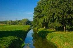 Myjava in the Záhorie Protected Landscape Area | |
| Location | |
| Countries | |
| Physical characteristics | |
| Source | |
| • location | near Nová Lhota, White Carpathians |
| • elevation | 660 m (2,170 ft) |
| Mouth | Morava River |
• location | Kúty |
• elevation | 152 m (499 ft) |
| Length | 79 km (49 mi) |
| Basin size | 806 km2 (311 sq mi) |
| Discharge | |
| • location | Štefanov |
| • average | 2.64 m3/s (93 cu ft/s) |
| • minimum | 0.2 m3/s (7.1 cu ft/s) |
| • maximum | 109 m3/s (3,800 cu ft/s) |
| Basin features | |
| Progression | Morava→ Danube→ Black Sea |
It rises in the White Carpathians near the village of Nová Lhota in Moravia, but crosses the Czech-Slovak border shortly afterwards and flows in a southern direction until the town of Myjava, where it enters the Myjava Hills and turns west. Near Sobotište it flows into the Záhorie Lowland and turns south until the village of Jablonica, turning northwest and from Senica it flows west, passing through Šaštín-Stráže and finally flowing into the Morava River near Kúty.
Etymology
The stem myj- comes from Proto-Slavic *myjǫ (Slovak: mytie, podmývanie) – to wash, to undermine river banks.[1]
gollark: But yes, you also entrust said random third parties with access to your information.
gollark: It's possibly more reliable as they have their own backups, but they may also just randomly lose data.
gollark: Yes. Very reliable. I too like having my data be read and/or stored at the whim of giant companies.
gollark: I might transfer my offline copy of wikipedia to the one on my phone.
gollark: They're perfectly acceptable for bulk data and stuff.
References
- Závodný, Andrej (2007). "O názvoch riek a potokov na Záhorí" [About river and creek names in Záhorie]. Záhorie (in Slovak) (1). Archived from the original on 2017-05-10.
This article is issued from Wikipedia. The text is licensed under Creative Commons - Attribution - Sharealike. Additional terms may apply for the media files.