Myanmar coastal rain forests
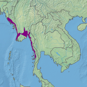
The Myanmar coastal rain forests is a tropical moist broadleaf forest ecoregion in Myanmar. The ecoregion occupies Myanmar's coastal lowlands along the Bay of Bengal and Andaman Sea.
| Myanmar coastal rain forests | |
|---|---|
 Mergui Village, southern Myanmar coast | |
 Ecoregion territory (in purple) | |
| Ecology | |
| Realm | Indomalayan realm |
| Biome | tropical and subtropical moist broadleaf forests |
| Borders | List
|
| Geography | |
| Area | 64,222 km2 (24,796 sq mi) |
| Countries | Myanmar |
| States and regions | Ayeyarwady Region, Bago Region, Kayin State, Mon State, Rakhine State, Tanintharyi Region and Yangon Region |
| Conservation | |
| Conservation status | Vulnerable |
| Protected | 3,534 km² (6%)[1] |
Geography
The Myanmar coastal rain forests occupy the coastal lowlands of Myanmar. It extends from the Naf River, which forms the border between Myanmar and Bangladesh, along the Rakhine coast. It also occupies the lower basins of the Irrawaddy and Sittaung rivers, and the coastal lowlands of Mon State and Tanintharyi Region along the Andaman Sea. In Rakhine it is bounded on the east by the Mizoram-Manipur-Kachin rain forests, which occupy the lower slopes of the Arakan Mountains. In the Irrawaddy and Sittaung basins, the Irrawaddy moist deciduous forests lie inland to the north, while the Irrawaddy freshwater swamp forests occupy the wide Irrawaddy Delta to the south. Further east, the Kayah-Karen montane rain forests and Tenasserim-South Thailand semi-evergreen rain forests cover the eastern mountains, and another enclave of the Irrawaddy moist deciduous forests lies in the lower Salween basin. The Myanmar Coast mangroves fringe the coast and river estuaries.[2]
Climate
The climate is humid and tropical. Rainfall is highest during the summer, when Southwest monsoon brings moisture-laden air from the Bay of Bengal.
Flora
The forests are mostly made up of evergreen or semi-evergreen trees. Dipterocarps are the predominant trees.[3]
Protected areas
A 2017 assessment found that 3,534 km², or 6%, of the ecoregion is in protected areas. About half the unprotected area is still forested.[4]
External links
- "Myanmar coastal rain forests". Terrestrial Ecoregions. World Wildlife Fund.
References
- Eric Dinerstein, David Olson, et al. (2017). An Ecoregion-Based Approach to Protecting Half the Terrestrial Realm, BioScience, Volume 67, Issue 6, June 2017, Pages 534–545; Supplemental material 2 table S1b.
- Wikramanayake, Eric; Eric Dinerstein; Colby J. Loucks; et al. (2002). Terrestrial Ecoregions of the Indo-Pacific: a Conservation Assessment. Washington, DC: Island Press.
- Wikramanayake, Eric; Eric Dinerstein; Colby J. Loucks; et al. (2002). Terrestrial Ecoregions of the Indo-Pacific: a Conservation Assessment. Washington, DC: Island Press.
- Eric Dinerstein, David Olson, et al. (2017). An Ecoregion-Based Approach to Protecting Half the Terrestrial Realm, BioScience, Volume 67, Issue 6, June 2017, Pages 534–545; Supplemental material 2 table S1b.