Mrouj
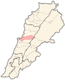
Mrouj (Arabic: المروج, also spelled Mrouje and El Mrouj) is a municipality in the Matn District of the Mount Lebanon Governorate of Lebanon. The English translation of Mrouj is "The Meadows"
Mrouj المروج | |
|---|---|
City | |
 Mrouj, 2015 | |
 Mrouj Location within Lebanon | |
| Coordinates: 33°54′45″N 35°44′57″E | |
| Country | |
| Governorate | Mount Lebanon Governorate |
| District | Matn District |
| Government | |
| • Mayors | Elie Dagher |
| Elevation | 1,220 m (4,000 ft) |
| Time zone | UTC+2 (EET) |
| • Summer (DST) | UTC+3 (EEST) |
| Dialing code | +961 |
Location
Mrouj is one of the Lebanese villages of the Metn district in Mount Lebanon. Mrouj overlooks Mount Sannine, Beskenta and Kesrouan to the north, and Metn south to the south.
Elevation is 1220 meters above sea level and is about 32 km from the capital Beirut. It is surrounded by a group of neighboring villages, the most important Bologna, wata El Muroj, El Mtein, Marjaba, and Al-zaarour famous ski resort 6 km north of Mrouj Church saints takla the village celebrate this great saint on September 24 of each year, the celebrations begin a week before and end after least a week. Also the village promotes summer vacation to escape the heat of the cities of the coast.
Water
Lake Mrouj is located approximately 3 km north of the town. It is a source of water for many villages in the Matn District
Economy
Mrouj is mostly a destination for summer tourism for Beirutis in the summer and ski enthusiasts in the winter. Zaarour ski resorts are about 6 km north of Mrouj
The town also hosts an annual festival for St. Takla in September in the St. Takla Square in the center of Mrouj
Education
There is a private [Catholic] school in the town. (Saint cœur Mrouj)
Religion
The inhabitants of Mrouj are almost all Christians, predominantly Maronites
St Takla Church was built approx in 1792
Churches
- Evangelical Church.
- St. Takla – Maronite.
