Mount Williams (Massachusetts)
Mount Williams is the 4th highest peak in the Commonwealth of Massachusetts. It is located in the Greylock Range in Berkshire County. Its altitude is 2,951 feet.
| Mount Williams | |
|---|---|
| Highest point | |
| Elevation | 2,951 ft (899 m) |
| Coordinates | 42°40′05″N 73°09′29″W |
| Geography | |
| Location | Berkshire County, Massachusetts |
| Parent range | Greylock Range |
Recreation
_%26_Mt._Prospect_(right).JPG)
Mt. Williams (on the left) Mt. Prospect (on the right) dominate the view from Route 2 near the Harriman-and-West Airport in North Adams, MA.
Located within the Mount Greylock State Reservation, approaches to this peak begin at a variety of trailheads within the Reservation. Parking is available at most trailheads. The Appalachian Trail traverses the summit of Mount Williams where there is a wide vista overlooking Williamstown and North Adams, MA as well as Pine Cobble Mountain to the north.
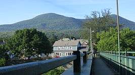
Mount Williams (the peak on the left) as seen from North Adams. The footbridge in the foreground spanning the Hoosic River and railroad tracks is part of the Appalachian Trail.
Geology, Geography & other information
Further details about Mount Williams are included in the adjacent mountain descriptions: Greylock, Fitch and Saddle Ball.
gollark: x86 has many registers.
gollark: PotatOS does not, exactly, *have* syscalls.
gollark: There should be an "install potatOS" syscall.
gollark: Is it installing potatOS in the background?
gollark: By the way, I may need to borrow your soul and/or 27% of your organs.
This article is issued from Wikipedia. The text is licensed under Creative Commons - Attribution - Sharealike. Additional terms may apply for the media files.