Mount Carnarvon
Mount Carnarvon is a 3,046-metre (9,993-foot) mountain summit located in the Kiwetinok River Valley of Yoho National Park, in the Canadian Rockies of British Columbia, Canada. Its nearest higher peak is The President, 3.9 km (2.4 mi) to the north-northeast.[2] Both are part of the President Range which is a subset of the Waputik Mountains.[2] Mount Carnarvon is situated five kilometers northwest of Emerald Lake, but is hidden from view behind Emerald Peak. However, Carnarvon is visible from Highway 1, the Trans-Canada Highway. The months July through September offer the most favorable weather for viewing or climbing Mount Carnarvon.
| Mount Carnarvon | |
|---|---|
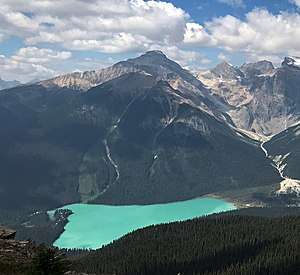 Mount Carnarvon seen with Emerald Lake from Mount Burgess | |
| Highest point | |
| Elevation | 3,046 m (9,993 ft) [1] |
| Prominence | 406 m (1,332 ft) [1] |
| Parent peak | The President (3123 m)[2] |
| Coordinates | 51°28′13″N 116°35′20″W [3] |
| Geography | |
 Mount Carnarvon Location of Mount Carnarvon in British Columbia  Mount Carnarvon Mount Carnarvon (Canada) | |
| Location | Yoho National Park British Columbia, Canada |
| Parent range | President Range Canadian Rockies |
| Topo map | NTS 82N/07[3] |
| Geology | |
| Age of rock | Cambrian |
| Type of rock | sedimentary rock |
| Climbing | |
| First ascent | 1904 by Dominion Topographic Survey |
| Easiest route | Scrambling |
History
Originally known as Emerald Mountain, the mountain was named in 1900 by Alexander MacKinnon Burgess (Commissioner of Public Lands) after Henry Herbert, 4th Earl of Carnarvon (1831-1890), who in 1867 authored the British North America Act which conferred self-government on Canada.[2] Then in 1874, he effected the settlement of difficulties between Canada and British Columbia on the "Carnarvon Terms".[4]
The first ascent of the mountain was made in 1904 by members of the Dominion Topographic Survey.[2]
The mountain's name was officially adopted in 1924 when approved by the Geographical Names Board of Canada.[3]
Geology
Mount Carnarvon is composed of sedimentary rock laid down during the Cambrian period. Formed in shallow seas, this sedimentary rock was pushed east and over the top of younger rock during the Laramide orogeny.[5]
Climate
Based on the Köppen climate classification, Mount Carnarvon is located in a subarctic climate with cold, snowy winters, and mild summers.[6] Temperatures can drop below −20 °C with wind chill factors below −30 °C. Precipitation runoff from Mount Carnarvon drains into tributaries of the Kicking Horse River.
References
- "Mount Carnarvon, British Columbia". Peakbagger.com.
- "Mount Carnarvon". Bivouac.com. Retrieved 2019-03-24.
- "Mount Carnarvon". Geographical Names Data Base. Natural Resources Canada. Retrieved 2019-03-24.
- BC Geographical Names
- Gadd, Ben (2008). "Geology of the Rocky Mountains and Columbias". Cite journal requires
|journal=(help) - Peel, M. C.; Finlayson, B. L. & McMahon, T. A. (2007). "Updated world map of the Köppen−Geiger climate classification". Hydrol. Earth Syst. Sci. 11: 1633–1644. ISSN 1027-5606.
External links
- Weather forecast
- Parks Canada web site: Yoho National Park
- Flickr photo: Carnarvon in winter