Mount Carmel, Hamden
Mount Carmel is a neighborhood in the northeastern portion of the town of Hamden, Connecticut. It was the site of the first meeting house in what is now Hamden. Its founders named the area due to the resemblance of a range of hills nearby to the Mount Carmel mentioned in the Bible.[1] The hills are better known today as the Sleeping Giant, site of a large state park known for its system of hiking trails. The neighborhood also contains the principal campus of Quinnipiac University. It is primarily residential with single-family homes.[2] Commercial development is mostly along its principal street, Whitney Avenue.
Mount Carmel | |
|---|---|
neighborhood | |
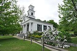 Mount Carmel Congregational Church | |
| Country | United States |
| State | Connecticut |
| County | New Haven |
| Town | Hamden |
| Population | |
| • Total | 7,726 |
As with all neighborhoods in Hamden, it has no officially-defined boundaries. One map[3] has it bounded on the north by the Cheshire and Wallingford town lines, on the east by the North Haven town line, on the south by James and Forest streets, and on the west by Farmington Canal Heritage Trail. The census tract with GEOID 09009166002, corresponding closely to these boundaries, had a population of 7,726, as of the 2010 census.
Historic sites
These sites are on the National Register of Historic Places:
- Jonathan Dickerman II House, serving as a museum for the Hamden Historical Society
- Sleeping Giant Tower, accessed by the principal trail in the park
- Farmington Canal (part)
- Elam Ives House
- Mount Carmel Congregational Church and Parish House
Government
The Town of Hamden provides all municipal services for the neighborhood. It is located in Connecticut's 3rd congressional district, the 11th state senate district, and the 88th state house district. Most of it is in the 1st district of the town legislative council, with smaller portions in the 4th and 9th.[9] It is served by the Centerville-Mt. Carmel post office with ZIP code 06518.
Transportation
Whitney Avenue extends north and south through the neighborhood, connected by the Mount Carmel Connector (Route 40) to I-91, by Mount Carmel Avenue to North Haven, and Tuttle Avenue to Wallingford.
CT Transit bus route 229, running between the downtowns of New Haven and Waterbury, operates along Whitney Avenue.[10]
Recreation
Sleeping Giant State Park offers hiking, picnicking, fishing, and youth group camping.[11] There are some 30 miles of trails on a variety of terrain. North of the park is the Sleeping Giant Golf Course, privately operated but open to the public.[12]
References
- Hartley, Rachel M. (1959). The History of Hamden, Connecticut, 1786-1959. p. 9.
- "Neighborhood Scout report on Mount Carmel".
- Hartley. History. Map in frontispiece.
- Hammond, Katheryn N. (1976). Historic Hamden: a guide. p. 24.
- Becker, Martha May (1986). Hamden: Our Architectural History. Whitney Press. p. 135.
- Hartley, Rachel M. (1959). The History of Hamden, Connecticut, 1786-1959. Shoe String Press. p. 256.
- "History of Quinnipiac University, Episode 1: Paving the Way".
- "Connecticut Roads, Route 40".
- "Hamden district maps".
- "CT Transit New Haven local system map" (PDF).
- "Sleeping Giant State Park".
- "Sleeping Giant Golf Course".