Moonambel
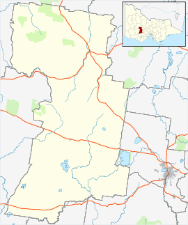
Moonambel is a small town in the Pyrenees region of the Australian state of Victoria, about 5 kilometres (3.1 mi) west of the Sunraysia Highway. It is in the Pyrenees Shire Local Government Area and near the heart of the Pyrenees wine region[3] in the Pyrenees Ranges.
| Moonambel Victoria | |||||||||||||||
|---|---|---|---|---|---|---|---|---|---|---|---|---|---|---|---|
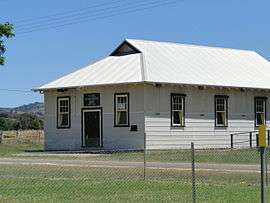 Mechanics Institute Moonambel | |||||||||||||||
 Moonambel | |||||||||||||||
| Coordinates | 36.984321°S 143.310974°E | ||||||||||||||
| Location |
| ||||||||||||||
| LGA(s) | Pyrenees Shire | ||||||||||||||
| State electorate(s) | Ripon[1] | ||||||||||||||
| Federal Division(s) | Mallee | ||||||||||||||
| |||||||||||||||
| Footnotes | [2] | ||||||||||||||
The population of Moonambel as recorded at the 2016 Census was 167 with a median age of 59.[4]
Moonambel's location in a valley and in a sparsely populated part of the state resulted in poor mobile phone reception which impacted on local residents, businesses and visiting tourists. A base station was funded under the Mobile Black Spot Program and built in 2017[5].
See also
References
- "Ripon District Profile". Victorian Electoral Commission. Retrieved 4 August 2015.
- "Moonambel". Gazetteer of Australia online. Geoscience Australia, Australian Government.
- "Wineries". Pyrenees Unearthed. Pyrenees Grape Growers & Winemakers. Retrieved 4 August 2015.
- "2016 Census QuickStats: Moonambel". quickstats.censusdata.abs.gov.au. Retrieved 19 May 2020.
- "Victoria's 50th New Mobile Tower Launched At Moonambel". Premier of Victoria. 27 June 2017. Retrieved 19 May 2020.
This article is issued from Wikipedia. The text is licensed under Creative Commons - Attribution - Sharealike. Additional terms may apply for the media files.