Montreuil-sur-Maine
Montreuil-sur-Maine is a commune in the Maine-et-Loire department in western France.
Montreuil-sur-Maine | |
|---|---|
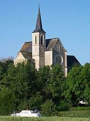
 The church in Montreuil-sur-Maine | |
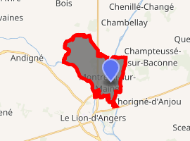
Location of Montreuil-sur-Maine 
| |
 Montreuil-sur-Maine  Montreuil-sur-Maine | |
| Coordinates: 47°39′04″N 0°41′44″W | |
| Country | France |
| Region | Pays de la Loire |
| Department | Maine-et-Loire |
| Arrondissement | Segré |
| Canton | Tiercé |
| Intercommunality | Vallées du Haut-Anjou |
| Government | |
| • Mayor (2008–2014) | Michel Chesneau |
| Area 1 | 11.13 km2 (4.30 sq mi) |
| Population (2017-01-01)[1] | 759 |
| • Density | 68/km2 (180/sq mi) |
| Demonym(s) | Montreuillais, Montreuillaise |
| Time zone | UTC+01:00 (CET) |
| • Summer (DST) | UTC+02:00 (CEST) |
| INSEE/Postal code | 49217 /49220 |
| Elevation | 17–61 m (56–200 ft) (avg. 53 m or 174 ft) |
| 1 French Land Register data, which excludes lakes, ponds, glaciers > 1 km2 (0.386 sq mi or 247 acres) and river estuaries. | |
Geography
The Oudon forms the commune's south-western border. The Mayenne flows south through the middle of the commune.
gollark: I was probably not planning to.
gollark: Fine, I'll just argonize more of your statements.
gollark: Orbital laser tracking initiated.
gollark: Wrong.
gollark: I am not obligated to so your statement is wrong and will be processed into argon.
References
- "Populations légales 2017". INSEE. Retrieved 6 January 2020.
| Wikimedia Commons has media related to Montreuil-sur-Maine. |
This article is issued from Wikipedia. The text is licensed under Creative Commons - Attribution - Sharealike. Additional terms may apply for the media files.