Montezuma, North Carolina
Montezuma is an unincorporated community in Avery County, North Carolina, United States. Before its founding in 1883, it had two variant names, Aaron and Bull Scrape. The community is located on Old State Highway 181 and is on the Eastern Continental Divide.
Montezuma | |
|---|---|
Unincorporated community | |
 Montezuma Location within the state of North Carolina | |
| Coordinates: 35°58′17″N 82°00′42″W | |
| Country | United States |
| State | North Carolina |
| County | Avery County |
| Founded | 1883 |
| Elevation | 3,766 ft (1,148 m) |
| Time zone | UTC-5 (Eastern (EST)) |
| • Summer (DST) | UTC-4 (EDT) |
| ZIP code | 28653 |
| Area code(s) | 828 |
| GNIS feature ID | 1013656[1] |
History
Between 1904 and 1940, Montezuma was a stop along the East Tennessee and Western North Carolina Railroad between Newland and Linville, with a spur to Pineola .
gollark: I think the jailbreak works by just using their ridiculously insecure update feature, actually.
gollark: I made a cool newsreader for my Kindle, actually, using the magic of RSS.
gollark: ... except the web browser, which *also* runs as root, um...
gollark: It was probably a bit of an afterthought, really, since they don't run too much untrusted stuff.
gollark: Slightly relatedly, Kindles are really insecure (with everything running as root) and can be jailbroken for full root access. There are some cool slightly useful unofficial kindle applications around.
References
Municipalities and communities of Avery County, North Carolina, United States | ||
|---|---|---|
| Towns | 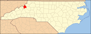 | |
| Villages | ||
| Unincorporated communities | ||
| Footnotes | ‡This populated place also has portions in an adjacent county or counties | |
This article is issued from Wikipedia. The text is licensed under Creative Commons - Attribution - Sharealike. Additional terms may apply for the media files.