Montemor-o-Novo
Montemor-o-Novo (Portuguese pronunciation: [mõtɨˈmɔɾ u ˈnovu] (![]()
Montemor-o-Novo | |
|---|---|
 Flag  Coat of arms | |
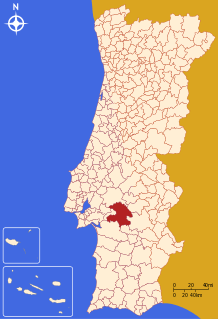 | |
| Coordinates: 38°39′N 8°13′W | |
| Country | |
| Region | Alentejo |
| Intermunic. comm. | Alentejo Central |
| District | Évora |
| Parishes | 7 |
| Government | |
| • President | Hortênsia Menino (CDU) |
| Area | |
| • Total | 1,232.97 km2 (476.05 sq mi) |
| Population (2011) | |
| • Total | 17,437 |
| • Density | 14/km2 (37/sq mi) |
| Time zone | UTC±00:00 (WET) |
| • Summer (DST) | UTC+01:00 (WEST) |
| Local holiday | Saint John of God March 8 |
| Website | http://www.cm-montemornovo.pt |
The present Mayor is Hortênsia Menino, elected by the Unitarian Democratic Coalition. The municipal holiday is March 8, after Saint John of God, a 16th-century saint, who was born in Montemor-o-Novo.
Parishes
Administratively, the municipality is divided into 7 civil parishes (freguesias):[4]
- Cabrela
- Ciborro
- Cortiçadas de Lavre e Lavre
- Foros de Vale de Figueira
- Nossa Senhora da Vila, Nossa Senhora do Bispo e Silveiras
- Santiago do Escoural
- São Cristóvão
 The city castle.
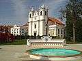 Town square.
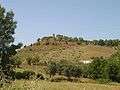 The local landscape.
gollark: They have a primitive bootloader, is all.
gollark: OR IS IT?
gollark: My school uses some clone called the "orange pip".
gollark: Wow, you must be lucky to have that actually work for you.
gollark: Genericization?
References
- Instituto Nacional de Estatística
- "Áreas das freguesias, concelhos, distritos e país". Archived from the original on 2018-11-05. Retrieved 2018-11-05.
- UMA POPULAÇÃO QUE SE URBANIZA, Uma avaliação recente - Cidades, 2004 Nuno Pires Soares, Instituto Geográfico Português (Geographic Institute of Portugal)
- Diário da República. "Law nr. 11-A/2013, page 552 77-78" (pdf) (in Portuguese). Retrieved 28 July 2014.
This article is issued from Wikipedia. The text is licensed under Creative Commons - Attribution - Sharealike. Additional terms may apply for the media files.