Montefiore, Tel Aviv
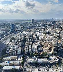
Montefiore (Hebrew: מונטיפיורי) is a neighborhood in the center of Tel Aviv, Israel.

Montefiore neighborhood

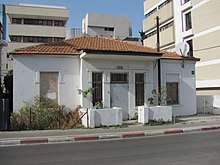
An old residential house in Montefiore neighbourhood
Geography
The Montefiore neighbourhood lies on the eastern edge of central Tel Aviv, about 2 kilometers from the Mediterranean coast, at an altitude of about 20 meters. At its eastern border, the Ayalon Motorway (Highway 20) passes along the railway line (on which the Ha-Shalom railway station is located) and the Ayalon River.[1][2]
gollark: Precisely.
gollark: It enhances them.
gollark: It doesn't "corrupt" signs.
gollark: The traffic light bit is wrong, the rest is fine.
gollark: No, that bit is right.
References
- "Montefiore, Tel Aviv, Israel" (in English and Hebrew). Google Maps. Retrieved 2011-07-02.
- "amudanan.co.il" (in Hebrew). amudanan.co.il. Retrieved 2011-07-02.
See also
This article is issued from Wikipedia. The text is licensed under Creative Commons - Attribution - Sharealike. Additional terms may apply for the media files.
