Montana Highway 84
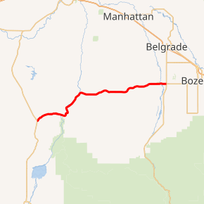
Highway 84 (MT 84) is a 28.904-mile-long (46.516 km) east–west state highway in the U.S. State of Montana. MT 84's western terminus is at U.S. Route 287 (US 287) in the small community of Norris and the eastern terminus is at US 191 and MT 85 at Four Corners. The highway's eastern terminus, about 7 miles (11 km) west of Bozeman, is a location known locally as "Four Corners." From Four Corners, US 191 runs east to Bozeman, and south to West Yellowstone; Highway 84 travels west to Norris; and Montana Highway 85 runs north to Belgrade.
| ||||
|---|---|---|---|---|

MT 84 highlighted in red | ||||
| Route information | ||||
| Maintained by MDT | ||||
| Length | 28.904 mi[1] (46.516 km) | |||
| Major junctions | ||||
| West end | ||||
| East end | ||||
| Location | ||||
| Counties | Gallatin, Madison | |||
| Highway system | ||||
| ||||
Before receiving its current designation, Highway 84 was designated as Montana Secondary Highway 289.
Major intersections
| County | Location | mi[1] | km | Destinations | Notes |
|---|---|---|---|---|---|
| Madison | Norris | 0.000 | 0.000 | ||
| Gallatin | | 25.081 | 40.364 | ||
| Four Corners | 28.904 | 46.516 | |||
| 1.000 mi = 1.609 km; 1.000 km = 0.621 mi | |||||
gollark: And fancy chemical whatever.
gollark: No, the output is a totally different value.
gollark: I don't know what you mean. Hash functions are just, well, mathematical functions, which take some arbitrary length value and output a fixed length output.
gollark: What?
gollark: Well, it would be much much faster and more accurate to just use dedicated hardware which... hashes them?
References
- Montana Department of Transportation (2013). "Montana Road Log" (PDF). Helena: Montana Department of Transportation. Retrieved November 25, 2015.
- Official 2009-2010 Montana Highway Travel Map (PDF) (Map). Montana Department of Transportation. Retrieved 2009-07-09.
This article is issued from Wikipedia. The text is licensed under Creative Commons - Attribution - Sharealike. Additional terms may apply for the media files.
